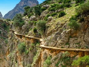
Route

Caminito del Rey

Mountain: La Maroma (2 069 m / 6 788 ft)
Activity type: Hiking
Activity level: Moderate
Elevation: 700 m / 2 297 ft
Duration: Please update
Expenses: Please update
Image of Caminito del Rey
Credit: www.expertvagabond.com

Overview

Route Name:
Caminito del Rey, エル・カミニート・デル・レイ, 카미니토 델 레이, Королевская тропа
Activity type:
Hiking
Activity level:
Moderate
Type of Climb:
Trekking
Location:
Europe, Spain: (Andalusia)
Starting Point:
Parent Range: Please update
Mountain:
First Ascent: Please update
Duration: Please update
Max. Elevation:
700m / 2 297 ft
Vertical Gain: Please update
Length:
8km / 5 miles
Climbing Season(s):
01 Apr-30 Sep;
Nearst
Airport(s):
Convenience Center(s):
National
Park(s):

Location

Europe, Spain: (Andalusia)
  • Your Chance To Edit •  Add / Share you knowledge with mates

  • Description Edit •  Add / Share you knowledge with mates

  • Getting There Edit •  Add / Share you knowledge with mates

    You can come by train or by road. If you choose a train, currently, RENFE train service offers regional trains on daily basis to El Chorro. The access road from Málaga to the path is the A-357, which is in good condition up to the Zalea crossroad. From there you can go along the same road to Ardales, or take the exit MA-5403 and go towards M-442 up to El Chorro. This road goes through a lush pine wood and around the Conde de Guadalhorce Reservoir. Your other option is to follow the A-343 road up to the crossroad at Pizarra and A-7077 that leads to Álora - El Chorro. Álora is 12 km away from El Chorro if you follow the road that goes up the Guadalhorce River. It is surrounded by beautiful landscape, wide orange or lemon trees orchards, and small hills with olive and almond grove in the higher zones. This is a curvy road but it offers magnificent view of the scenery above all during the flowering season when orange, lemon and almond trees become stunningly beautiful. This way goes through the small villages of Caracuel and Bermejo (where you can find restaurants, a chemist, a tobacconist's and grocery stores) to El Chorro village where varied services are provided such as train station, shuttle bus stop where you can take the bus to the northern entrance to El Caminito del Rey, the Tourist Office, the Reception Centre, a car park, as well as restaurants and accommodation.
  • Are You Ready? Edit •  Add / Share you knowledge with mates

  • Tips Edit •  Add / Share you knowledge with mates

    Cellular Network: No (Guided Tours)


  • Parameters Edit •  Add / Share you knowledge with mates

    Base Camp Elevation: Please update
    Summit Camp Elevation: Please update
    Accommodation in Base Camp: Please update
    Accommodation above Base Camp: Please update
    Number of Camps: Please update
    Avg. Cost: Please update
    Age Restrictions: Please update
    Soloing: Please update
    Descent Route: Same
    Specify descent time: Please update
  • Key Points Edit •  Add / Share you knowledge with mates

    Name (Elevation) Description
  • Agencies Edit •  Add / Share you knowledge with mates

  • GPS-Tracks

    Add
  • Did You Know Edit •  Add / Share you knowledge with mates

  • References Edit •  Add / Share you knowledge with mates

Last update: (30 Aug 2017) • History
No one has been added yet

0 climber who were here

Sort by:

show:

  • 6
  • 18
  • 36

Join the growing Alpine Community now.