Route
verified

Dhaulagiri Base Camp Trek, Himalaya

Mountain: Dhaulagiri (8 167 m / 26 795 ft)
Activity type: Hiking
Activity level: Challenging
Elevation: 5 360 m / 17 585 ft
Duration: 13 Day(s)
Expenses: from$ 1 500
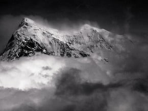
Image of Dhaulagiri Base Camp Trek, Himalaya
Credit: http://images.summitpost.org/origin...

Overview

Route Name:
Dhaulagiri Base Camp Trek, Trekking to the Dhaulagiri Base Camp, Треккинг в Базовый Лагерь Дхаулагири
Activity type:
Hiking
Activity level:
Challenging
Type of Climb:
Trekking
Location:
Asia, Nepal: (Western Region)
Starting Point:
Parent Range:
Mountain:
First Ascent:
1/1/2015
Duration:
13 Day(s)
Max. Elevation:
5 360m / 17 585 ft
Vertical Gain:
4 290m / 14 075 ft
Length:
100km / 62 miles
Climbing Season(s):
01 Apr-31 May;
01 Sep-30 Nov;
Nearst
Airport(s):
Convenience Center(s):
National
Park(s):

Location

Asia, Nepal: (Western Region)
Guided Tour

Location: Nepal

Price: $0
10 Day(s)

Activity type:Hiking

Difficulty: Moderate/ Challenging

0 reviews
Add to wishlist
Guided Tour

Location: Nepal

Price: $0
12 Day(s)

Activity type:Hiking

Difficulty: Moderate/ Challenging

0 reviews
Add to wishlist
Guided Tour

Location: Nepal

Hot Deal: $6500
Price: $7500
34 Day(s)

Activity type:Mountaineering

Difficulty: Challenging

0 reviews
Add to wishlist
  • Your Chance To Edit •  Add / Share you knowledge with mates

    From rice fields, dense forests and nice villages with full service you'll get to rocks, glaciers, moraines and snow fields, where you'll meet only few trekkers. You'll spend your nights in tents and will experience a real life of a mountaineer, and besides this is above 4500 m. You'll walk through two high passes and the Hidden valley above 5000 m. Charming views of high mountains and snow peaks (especially Dhaulagiri I (8167 m), Annapurna I (8091 m)) will make this trek unforgetable.
  • Description Edit •  Add / Share you knowledge with mates

    The distance of this route is about 100 km. It takes 11-12 days. This route combines gentle walking along nice trails through fields and forests with hiking in highlands by glaciers and snow fields. The altitude change is from 1070 m (Naya Pul) to 5360 m (the French Pass). During the first part of the route you stay at lodges and eat in restaurants. Then you have 6-8 days in tents. The main part of the route lies above 4500 m and you'll spend several days over 5000 m. During the high part strong wind can blow and the temperature can be down to -25 °C.
  • Getting There Edit •  Add / Share you knowledge with mates

    You can reach the starting point from Pokhara by bus or taxi.
  • Red Tape Edit •  Add / Share you knowledge with mates

    It's necessary to have Annapurna Conservation Area Entry Permit and TIMS Card. Entry Permit you can get in Kathmandu (Nepal Tourism Board, Bhrikutimandap, open hours 9 - 17), Pokhara (Nepal Tourism Board, Tourist Service Centre, Pardi Damside, open hours 10 - 17). You'll need 2 passport size photographs, a photo-copy of passport, form filled in, health insurance policy information. This Entry Permit is valid for single entry only and must be carried during the entire trip. Period of staying in the area is not defined. TIMS Card you can also get in NTB of Kathmandu and Pokhara. You'll need 2 passport size photographs and a photo-copy of passport. You have to pay fees for both Entry Permit and TIMS Card.
  • Are You Ready? Edit •  Add / Share you knowledge with mates

    This route is more challenging than the classic "tea-house trekking". It requires good physical fitness and some previous trekking/mountaineering experience, including living in a tent and hiking in highland. In specific circumstances some special techniques (using crampons, ice-axe, rope) may be useful.
  • Tips Edit •  Add / Share you knowledge with mates

    Cellular Network: Yes (Logistics)

    Mobile Internet: No (There is cell coverage in the beginning and in the end of this route. There is no network in the high part of the route.)


    The main trail on this route is marked, however sometimes there can be difficulties in finding the way, so it's recommended to have a map (be careful, because some maps have mistakes) and some skills of orientation (especially if you go by yourself, without a guide). Ascent from Tukuche till 4900 m is quite steep. Then there is a long traverse of a steep slope. Approaching the Dhampus Pass the trail can be covered with snow and be less comfortable. And sometimes avalanche danger may present here. Descending from the French Pass a rope can be useful on a steep parts of the trail. In the Dhaulagiri Base Camp and in the Hidden valley can blow strong winds during the night and in the morning. It's important to put the tents right and securely. The night temperature there can be down to - 25 °C. The snow can also cause some difficulties while hiking around 5000 m. In the area of the Dhampus pass the sudden whiteouts are possible. And the final challenge of the route is the long and steep descent to the Kali Gandaki valley (toward Marpha).

  • Parameters Edit •  Add / Share you knowledge with mates

    Base Camp Elevation: 1 070 m / 3 511 ft
    Summit Camp Elevation: Please update
    Accommodation in Base Camp: Both - huts and tents
    Accommodation above Base Camp: Huts only
    Number of Camps: 13
    Avg. Cost: 1 500 USD
    Age Restrictions: 0
    Soloing: Yes
    Descent Route: Same
    Specify descent time: 0 Day(s)
  • Key Points Edit •  Add / Share you knowledge with mates

    Name (Elevation) Description
    Naya Pul
    1 070 m / 3 511 tf
    It's a village where you can take a taxi or the bus to Pokhara.
    Tikhedhunga
    1 577 m / 5 174 tf
    Here you can have launch or stay overnight in a lodge.
    Ghorepani
    2 840 m / 9 318 tf
    The main village is situated a little bit east of the Gorepani pass and most trekkers will only see the lodge settlement on the pass. There are several lodges.
    Tatopani
    1 200 m / 3 937 tf
    This village is famous for its hot springs and good food. There are several lodges in Tatopani, but as people coming from the AC and from Ghorepani it can be difficult to get the place in your favorite lodge if you arrive in the afternoon. The hot springs are near the river just protected from the road by a wall. There are also check post and money changer.
    Tukuche
    2 590 m / 8 497 tf
    This is an old Thakali village. Once it was the toll place for the salt trade with Tibet and still you see the large houses used as caravansary. One can evaluate the wealth of Tukuche looking at the beautiful carved wooden windows.
    Yak Kharka
    3 680 m / 12 074 tf
    There are plaves for tents near few huts and fields of summer pastures.
    Kalapani
    4 900 m / 16 076 tf
    There are a few flattened camping spots among the barren rock, that you can use if you need 2 days to do up from Yak Kharka to the Dhampus Pass. There can be water nearby (unless you'll have snow to melt).
    The Dhampus Pass
    5 258 m / 17 251 tf
    This pass is covered with snow. From the northwest the trail goes through snowfields with gentle ascent. And from the southeast side the trail crosses a steep snow slope. On the saddle there are cairn and prayer flags.
    The Hidden valley
    5 100 m / 16 732 tf
    This is an uninhabited valley almost bare with winds blowing most of the time and very cold night temperatures.
    The French Pass
    5 360 m / 17 585 tf
    This pass is covered with snow. The southwest slope is quite steep, and the northeast one is gentle. The saddle is big and flat with a cairn and some prayer flags. This pass is the way between the valley of Myagdi Kola river and the Hidden Valley.
    Dhaulagiri Base Camp
    4 700 m / 15 420 tf
    The base camp is located on the glacier. There can be several areas with places for tents between 4600 m and 4700 m. It's better to stay in the higher one.
    Marpha
    2 700 m / 8 858 tf
    Marpha is one of the places should not miss and you could have some very nice hours exploring it. Here you can find internet, safe drinking water station and money changer.
    Jomsom
    2 720 m / 8 924 tf
    There is new and old parts of the village. There are a lot of lodges, ACAP office, Police check post, safe drinking water station, internet and the airport).
  • Agencies Edit •  Add / Share you knowledge with mates

    Guided Tours
  • GPS-Tracks

    Add
  • Did You Know Edit •  Add / Share you knowledge with mates

    The highest point of the Dhaulagiri Base Camp trek is the French Pass (5360 m). It is called so in honor of a french mountaineer Maurice Herzog. His expedition in 1950 was first to see the Hidden Valley from this pass. They were exploring this area looking for a possible route to the Dhaulagiri I (8167 m).   ... Read more
  • References Edit •  Add / Share you knowledge with mates

Last update: (27 Jun 2018) • History
No one has been added yet

0 climber who were here

Day 1


Naya Pul - Tikhedhunga. A good trail along the river goes through Birethanti (1015 m) and Hille (1495 m) and leads to Tikhedhunga (1577 m), where you can stay overnight at a local guesthouse (lodge).

Read more
Day 2


Tikhedhunga - Ghorepani. At first there is a steep ascent to the village Ulleri (about 500 m with stone stairs). From Ulleri the trail ascends more gently through the fine forests and reaches Ghorepani where you can stay overnight at a lodge.

Read more
Day 3


Ghorepani - Tatopani. The trail descends gently, ascending sometimes on little hills. There are hot springs in Tatopani. You can spend the night in a lodge.

Read more
Day 4


Tatopani - Ghasa. The trail today gently ascends and goes through cypress and cedar's forest. In Ghasa overnight stay in a lodge.

Read more
Day 5


Ghasa - Tukuche. On the right side of the river Kali Gandaki the road goes, where the main trail was, but there is a new trail on the left side of the river, There are bridges near Kalopani and Tukuche. The overnight stay in a lodge.

Read more
Day 6


Tukuche - Yak Kharka. The trail ascends steeply to the meadows of Yak Kharka, the first overnight stay in tents.

Read more
Day 7


Yak Kharka - Kalapani. The trail traverse the slope, ascending rather steeply at first, but then ascent becomes more gentle. After crossing several minor ravines, which may have water, there are a few flattened camping spots among the barren rock (at 4900 m). This is Kalapani (black water), the usual camping spot.

Read more
Day 8


Kalapani - the Dhampus pass (5258 m) - Hidden Valley. From Kalapani the trail continues contouring and gently rising to the pass. The slope is quite steep and can be avalanche-pone. Descent to Hiden valley is gentle and snowy. From the Dhampus pass you can climb up to the Dhampus Peak (6035 m).

Read more
Day 9


Hidden Valley - the French Pass (5360 m) - Dhaulagiri Base Camp. Ascent to the French Pass from the Hidden valley is gentle and snowy. The descent is gentle at first and marked with the cairns. First you follow the top of the moraine wall ant then abruptly descend to the glacier. This is steep and potentially dangerous passage, using the rope may be necessary. Once on the ice move quickly since avalanches can land uncomfortably close. The trail to the Dhaulagiri BC is usually clear and may be not the same as marked in the maps. Dhaulagiri BC is merely a collection of flat tent spots on glacier rubble and it is usually marked by flags.

Read more
Day 10


The rest day in the Dhaulagiri Base Camp.

Read more
Day 11


Dhaulagiri base camp - the French Pass – Hidden valley. First the trail continues by the glacier, then does up to the ledge, crosses the snow field and leads to a short but steep ascent to the saddle of the French pass. It can be really difficult because of the snow. Decent from the pass by the glacier is not a problem.

Read more
Day 12


Hidden valley - the Dhampus Pass (5258 m) – Yak Kharka. The path to the Dhampus Pass is marked with cairns, but still it can be tricky to find them and the best way to the pass. The ascent is gentle and can be snowy. The descent is rather steep, first along snowy slopes. Then the trail leads to scree slopes, and then goes down and sometimes could be lost in the maze of yak trails.

Read more
Day 13


Yak Kharka – Marpha - Jomsom. A very steep and long descent to Kali Gandaki valley. The main trail is well marked. From Marpha to Jomsom you can get trekking or rent a jeep.

Read more
Sort by:

show:

  • 6
  • 18
  • 36

Join the growing Alpine Community now.