Route
verified

Kanchenjunga Trek, Himalaya

Mountain: Kangchenjunga (8 586 m / 28 169 ft)
Activity type: Hiking
Activity level: Challenging
Elevation: 1 780 m / 5 840 ft
Duration: 8 Day(s)
Expenses: from$ 600
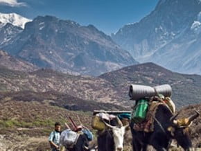
Image of Kanchenjunga Trek, Himalaya
Credit: www.khumbutreks.com

Overview

Route Name:
Kanchenjunga Trek, Goecha La Trek, Трекинг к перевалу Гоча-Ла, Канченджанга, Трекинг к Канченджанге
Activity type:
Hiking
Activity level:
Challenging
Type of Climb:
Trekking
Location:
Asia, India: (State of Sikkim)
Starting Point:
Parent Range:
Mountain:
First Ascent:
??/1/1979 Pete Boardman
Duration:
8 Day(s)
Max. Elevation:
1 780m / 5 840 ft
Vertical Gain:
3 220m / 10 564 ft
Length:
88km / 55 miles
Climbing Season(s):
15 Mar-15 Jun;
01 Oct-15 Dec;
Nearst
Airport(s):
Convenience Center(s):
National
Park(s):

Location

Asia, India: (State of Sikkim)
  • Your Chance To Edit •  Add / Share you knowledge with mates

    "...Sikkim... Nowhere else is there such a sparkling, such a spiritual richness like amongst these precious snows... Here the great hermits came because where else in two days it is possible to climb from tropical vegetation to eternal snow... Sikkim is inviting." (N. K. Roerich) An unforgettable journey along the former secret Kingdom of Sikkim. Trekking to the third Eight-thousander of the planet - Kanchenjunga - brings you to the heart of majestic summits of the Eastern Himalayas. The target of the route is Goecha La Pass (4 940m), from where a spectacular view to that beautiful mountain. Following the route you will hike from lush rainforests to the stone deserts and snows.
  • Description Edit •  Add / Share you knowledge with mates

    The route lays in Indian Eastern Himalayas. It begins in the old capital of the former Kingdom of Sikkim, named Yuksam. While hiking you will ascend from subtropical rainforest to the snowy desert and high mountain Goecha La Pass (4 940m).
  • Getting There Edit •  Add / Share you knowledge with mates

    Domestic flight to Bagdogra from New Delhi or Calcutta domestic airports. Then long transfer (approximately 280 km along mountain roads) to Yuksam.
  • Red Tape Edit •  Add / Share you knowledge with mates

    To access the route one has to get the permission for visiting the National Park Kangchendzonga. To obtain a permit it's necessary to pay a fee at a Check post or at Wildlife Education and Interpretation Centre in Yuksom. However, it's not possible to get to Sikkim independently because this state requires a visa. A traveller can get a visa on the border of Sikkim with the help of a local tour operator.
  • Are You Ready? Edit •  Add / Share you knowledge with mates

    Trekking requires cardiovascular endurance (via aerobic training), strength endurance (through strength conditioning), and hiking-specific training (via hiking with a pack). Being in strong physical shape is one of the most important aspects for success on a high altitude trek. During your training, you should be planning to progressively ramp up your speed, duration (time or mileage), and pack weight of weekly training hikes to give you hiking-specific conditioning that cannot be matched by any other sort of training.
  • Tips Edit •  Add / Share you knowledge with mates

    Cellular Network: Yes (Accomodation)

    Mobile Internet: Yes (Cellular network covers all the way until Yuksam (1 700 m). There is no coverage above.)


    To do the trek you will have to contact a local tour operator - these are the rules for all of the travellers in mountain areas of Sikkim. During the trekking you can be accommodated only in lodges or tents, excluding Yuksam where there are some hotels. Don't forget to take some money for tips to pay after your trekking finishes. Usually it's 10% of the trekking's cost. You don't need any kind of vaccination for visiting India but in any case you have to be very attentive to these criteria: drink only bottled water or water after boiling and no ice, don't buy dubious drinks or foods, don't buy food on the streets, wash your hands regularly. If you are going to visit southern areas of India don't forget to bring special tablets to protect yourself from malaria. It will be Lariam, Doxycycline or Malarone that is the most effective one.

  • Parameters Edit •  Add / Share you knowledge with mates

    Base Camp Elevation: 4 920 m / 16 142 ft
    Summit Camp Elevation: Please update
    Accommodation in Base Camp: Both - huts and tents
    Accommodation above Base Camp: Tents only
    Number of Camps: 5
    Avg. Cost: 600 USD
    Age Restrictions: 16
    Soloing: Yes
    Descent Route: Another Route -Please update
    Specify descent time: 3 Day(s)
  • Key Points Edit •  Add / Share you knowledge with mates

    Name (Elevation) Description
    Yuksam
    1 780 m / 5 840 tf
    Old capital of Sikkim Kingdom (now Sikkim is one of the Indian states). Tourist centre and the start point of the routes.
    Tsokha
    3 000 m / 9 843 tf
    A little village with some houses and a tiny Buddhist monastery.
    Dzongri
    4 000 m / 13 123 tf
    A camping site that is located not far from the Himalayan Mountaineering Institute's base camp.
    Daplangang
    4 180 m / 13 714 tf
    A view point with the best view on the Himalaya and Kanchenjunga.
    Rangeet
    0 m / 0 tf
    A river.
    Tangsing
    3 900 m / 12 795 tf
    A camp site with stunning views of Kanchenjunga and Pandim Mountains.
    Lamuni
    4 160 m / 13 648 tf
    A holy Buddhist place. Base camp for travellers who is going to climb Goecha La Pass.
    Goecha La
    4 940 m / 16 207 tf
    The route's target. High mountain pass from where you can see spectacular Kanchenjunga.
    Samiti
    0 m / 0 tf
    A sacred lake.
    Kokchurong
    3 680 m / 12 074 tf
    A camp site on the bank of Rangeet river.
  • Agencies Edit •  Add / Share you knowledge with mates

    Guided Tours
  • GPS-Tracks

    Add
  • Did You Know Edit •  Add / Share you knowledge with mates

    In addition to Goecha La Pass there is also the second Goecha La Pass. It is situated not far from the "first" one (approx. 1 km away) and its altitude is 5 000 м. Ask your guide wether you will be allowed to go there if the pass is open for visits.


  • References Edit •  Add / Share you knowledge with mates

Last update: (27 Apr 2017) • History
No one has been added yet

0 climber who were here

Day 1


Trekking starts from the old capital of Sikkim named Yuksam (1 780m). The path brings you to Tsokha (3 000 m). Be prepared for a moderately difficult but beautiful journey. You'll proceed along the river valley through dense subtropical rainforest where huge rhododendrons grow. Last 3 km will be the most difficult because of the steep slope ascending. And here you are - in a small Tsokha village with its dozen houses and a tiny monastery.

Read more
Day 2


Hiking to Dzongri (4 000m). It is one of the most sacred Buddhist places because one of the four "Great Caves" located close by.

Read more
Day 3


Be sure to start early (before 4am). A short walk to Daplangang view point (4 180m). You will enjoy the best mountain panorama in Sikkim and sunrise above Kanchenjunga. It will be good for your acclimatisation to ascend to Dzongri La Pass (4 380m) and to visit the Himalayan Mountaineering Institute's base camp. Return to Dzongri.

Read more
Day 4


Steep descending through the rhododendron forest to Rangeet river. Smooth ascent along mountain river to Tangsing (3 900m).

Read more
Day 5


This morning you will be stunned by the views of Kanchenjunga and Pandim peaks. Hiking to the holy spot Lamuni (4 160m) along the river valley.

Read more
Day 6


Start before 4am. If you will be lucky you will have a chance to see the sunrise above Kanchenjunga at the view point. It's unforgettable! Climb to Goecha La Pass (4 940m). It's a sacred place that attracts travellers from all over the world. Descent back along the same route. Short rest near holy Samiti Lake. Return to Lamuni and hiking further to Kokchurong (3 680m). The path follows the ancient caravan track that joined India and Tibet. That path also follows the Central Asian expedition of famous Russian artist and explorer Roerich and the way of Nepalese and British squadrons during the Tibet invasion. Overnight on the bank of Rangeet river.

Read more
Day 7


Return to Tsokha, descending along the river valley.

Read more
Day 8


Descent to Yuksam.

Read more
Sort by:

show:

  • 6
  • 18
  • 36

Join the growing Alpine Community now.