Route
verified

Mount Kailash Trek, Tibetan Plateau

Mountain: Mount Kailash (6 638 m / 21 778 ft)
Activity type: Hiking
Activity level: Moderate
Elevation: 5 630 m / 18 471 ft
Duration: 3 Day(s)
Expenses: from$ 2 000

Overview

Route Name:
Mount Kailash Trek, Kora around the Mt. Kailash, Mt. Kailash Parikrama, Кора вокруг горы Кайлаш, Парикрама вокруг горы Кайлаш, Kora, Cora, Кора, Треккинг вокруг Кайлаша
Activity type:
Hiking
Activity level:
Moderate
Type of Climb:
Trekking
Location:
Asia, China: (Tibet Autonomous Region)
Starting Point:
Parent Range:
Mountain:
First Ascent:
1/1/2015
Duration:
3 Day(s)
Max. Elevation:
5 630m / 18 471 ft
Vertical Gain:
1 000m / 3 281 ft
Length:
56km / 35 miles
Climbing Season(s):
01 Apr-31 Oct;
Nearst
Airport(s):
Convenience Center(s):
National
Park(s):
Please update

Location

Asia, China: (Tibet Autonomous Region)
  • Your Chance To Edit •  Add / Share you knowledge with mates

    This short-distanced and technically easy route gives you an opportunity to spend unforgettable time in high mountains and enjoy marvelous views and clear mountain air. On the route you'll find nice trails going slightly up and down, as well as steep ascent and descent of the pass. Each day will bring something new. Here you can feel the atmosphere of Eastern believes and tranquillity.
  • Description Edit •  Add / Share you knowledge with mates

    The distance of this route is about 55 km. Usual duration is 3 days. Altitude is above 4600 m. The highest point is 5630 m (the pass, that leads from one valley to another). From different spots of the route you can see Mt. Kailash. And from the northern side you can get closer to it in a 2-3 hours walk up to the glacier. To walk this route you should be in a good health and fit and you don't need any special skills. To enter this region you have to contact any local tourist agency that will provide you with a guide, a car and all requiered permits.
  • Getting There Edit •  Add / Share you knowledge with mates

    You can reach Darchen (starting point of this route) from Lhasa (China, Tibet Autonomous Region) driving a car for more than 1000 km. You can get to Lhasa by plane or train. There is another way to get to Darchen - driving from Kathmandu (Nepal). This way is a little shorter.
  • Red Tape Edit •  Add / Share you knowledge with mates

    Today to get to Mt. Kailash all foreigners must hire a licensed tour guide and rent a land cruiser using services of any local travel agency. Travel agent will also get all requiered permissions: Tibet Entry Permit (issued by Tibet Tourism Bureau), Military Permit (getting these takes about 3 weeks, requieres copy of passport and Chinese visa and should be done in advance) and Alien's Travel Permit (issued by Public Security Bureau) (you get this right in Lhasa providing the original of your passport). If you enter the region from Nepal (Kathmandu), then you get Chinese group visa (Chinese visa and Tibet Entry Permit in one). The travel situation in Tibet is changing vastly the last years, so you should find out the actual circumstances while planning your trip. It's important to consider, that Chinese government can close this region for some periods during the year.
  • Are You Ready? Edit •  Add / Share you knowledge with mates

    To make this route you don't need to posses any special mountaineering skills, but you should be in a good health and fit. It means that you can be ready to hike up to 20 km per day at the altitude 4 000 meters above sea level. And before the start you should get an appropriate altitude acclimatization.
  • Tips Edit •  Add / Share you knowledge with mates

    Cellular Network: Yes (Accomodation)

    Mobile Internet: Yes (You can buy local sim-card (with passport and colored foto) and get the access to Internet all along the trek.)


    Usually this route takes three days (with good whether and middle speed), but one can make it faster (even for one day with proper training) or in more leisurely way. Most people walk around Mt. Kailash clockwise, but some walk in opposite direction. You can walk all the way, carrying your stuff, or you can ease wour walk in several ways. For example drive to the start of kora itself and from the end to Darchen (this will save about 10 km). You can ride a horse and hire yaks to carry your luggage. On the route you can spend nights in tent or in guesthouses or monasteries. Service in those last is very simple (as well as in Darchen). If you stay in tent you have to pay for your guide's place in a guesthouse anyway. In some periods of the season all beds in guesthouses can be booked. There are tents with food and beverage (including still water) for sale in several places along the route. You can also drink boiled or purified water from the rivers. It's important to understand, that Mt. Kailash is a sacred place for several religions. So on the route and in the places of overnight staying you can meet a lot of pilgrims performing their rituals.

  • Parameters Edit •  Add / Share you knowledge with mates

    Base Camp Elevation: 4 675 m / 15 338 ft
    Summit Camp Elevation: Please update
    Accommodation in Base Camp: Both - huts and tents
    Accommodation above Base Camp: Huts only
    Number of Camps: 2
    Avg. Cost: 2 000 USD
    Age Restrictions: 8
    Soloing: Yes
    Descent Route: Same
    Specify descent time: 0 Day(s)
  • Key Points Edit •  Add / Share you knowledge with mates

    Name (Elevation) Description
    Darchen
    4 675 m / 15 338 tf
    This small village in Barkha valley is the starting and the ending point of this route.
    First crain on the route
    4 770 m / 15 650 tf
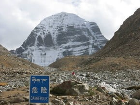
    The cairn is bedecked with prayer flags and marks the first views of Mt Kailash’s southern face.
    Tarboche
    4 730 m / 15 518 tf
    This is a place, where the road enters the valley of Lha-chu river, crossing the ridge from the southern to the western side of Mt. Kailash. Here are a lot of prayer flags. In this spot the festival Saga Dawa takes place (on the 15th of April).
    Chuku monastery
    4 850 m / 15 912 tf
    Monastery in the Lha-chu valley, on it's west side, abobe the road (100 m). A few nomad tents may be set up on the other side of the river from the monastery, with food and water for sale.
    Diraphuk monastery
    5 100 m / 16 732 tf
    Monastery on the right bank of the river Lha-chu, on the nothern side of Mt. Kailash. The first overnight is usually in this area.
    Shiva-tsal
    5 330 m / 17 487 tf
    A rocky expanse where pilgrims leave their ald cloths.
    Drolma La Pass
    5 630 m / 18 471 tf
    This pass is the highest point of the route and leads from the western to the eastern valley around Mt. Kailash. The saddle is vast and rocky.
    Gauri Kund Lake
    5 570 m / 18 274 tf
    Small lake near the saddle on the east side of the Drolma La Pass
    Zutulpuk Monastery
    4 790 m / 15 715 tf
    Monastery in the valley of the river Lham-chu Khir on the eastern side of Mt. Kailash. The second overnight is usually in this area.
  • Agencies Edit •  Add / Share you knowledge with mates

  • GPS-Tracks

    Add
  • Did You Know Edit •  Add / Share you knowledge with mates

    Just 40 years ago Tibet Autonomous Region and Mt. Kailash area were closed for foreigners. And till today it's forbidden to climb up to the summit of Mt. Kailash.


    In 1985 legendary mountaineer Reinhold Messner was awarded a permit to climb Mt. Kailash, that is considered sacred to several
      ... Read more
  • References Edit •  Add / Share you knowledge with mates

Last update: Slava Shevtsov (27 Jun 2018) • History
No one has been added yet

0 climber who were here

Day 1


The Kailash kora usually begins on the western edge of Darchen. Only 4km from Darchen the trail climbs up over the southwest end of a east–west ridge to reach a cairn at 4730m. The cairn is bedecked with prayer flags and marks the first views of Mt Kailash’s southern. Very quickly the trail bends round to the north and enters the barren Lha-chu Valley. From here on, the narrow Lha-chu River provides a steady supply of water all the way to Dira-puk Monastery. After passing a series of ruined chörtens and a number of long mani (prayer) walls, the trail reaches a small bridge across the Lha-chu at 4710m. The bridge is about three hours’ walk from Darchen and is directly below Chuku Monastery perched high above the valley floor on the hillside to the west. During the pilgrim season, a few nomad tents may be set up on the other side of the river from the monastery, with food (instant noodles and snacks) and water for sale. From the Chuku bridge there are alternative trails along the east and west banks of the river. The trail along the eastern bank is the regular pilgrim route, but on the western trail there are some fine grassy camp sites at Damding Donkhang (4890m). Either way it’s about three hours to Dira-puk Monastery, where is another bridge. From this point you can see the northern side of Mt. Kailash and can walk towards the mount up to the Kangkyam Glacier.

Read more
Day 2


From Dirapuk Monastery the trail goes on the east bank of the river and in two hours reaches a rocky expanse of Shivatsal (5330m). There's plenty of stone cairns draped with items of clothing. About 30 minutes from Shivatsal the trail turns eastward for the completion of the ascent to the highest point of this route - 5630m Drolma La Pass. There's Gauri Kund Lake right under the pass on its east side. Descent from Domla La Pass to the grassy banks of the Lham-chu Khir is long and very steep and takes approximately an hour. In the valley there are two routes that follow both sides of the river. The eastern-bank trail presents better views and there’s less marshy ground but it requires crossing the river by boulder hopping. About three hours on, grassy fields appear alongside the river affording those with tents endless spots to set up camp. An hour or so from the start of the camping fields is the Zutulpuk Monastery (4790m).

Read more
Day 3


From the Zutulpuk Monastery, the trail follows the river closely for an hour or so, then climbs above the river and enters a narrow canyon. When the trail emerges onto the Barkha plain, it’s now an easy one-hour walk back to Darchen along a dirt road.

Read more
Sort by:

show:

  • 6
  • 18
  • 36

Join the growing Alpine Community now.