

Kedartal Trek, Mount. Thalaysagar Base Camp
| Activity type: | Hiking |
| Activity level: | Challenging |
| Availability: |
5 May 2020 - 10 May 2020 |
| Duration: | 1-99 Day(s) / Daily Rate |
| Price: | from $250 / Negotiable |
Full description
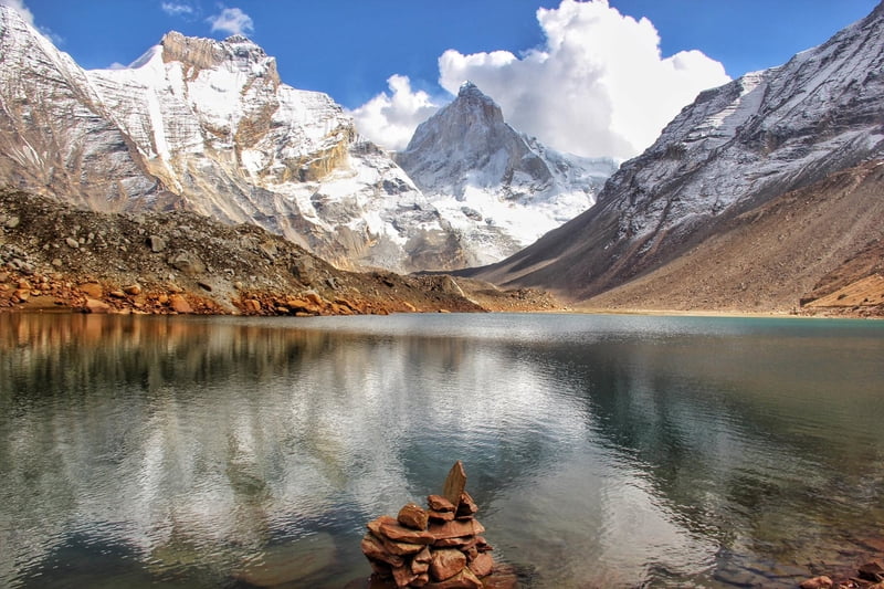
KedarTal is an emerald lake situated next to Kedar Bamak Glacier at the foot of the enormous Thalaysagar (6,904) and Brigupanth Peak (6,772mts). Kedar Bamak Glacier is the source of Kedar Ganga which acts as an important tributary of Bhagirathi River. At 4780mts above sea level, Kedartal is one of the most beautiful high altitude lakes of India.
Price includes
- 1. Accommodation for 2 Night in Gangotri
- 2. All Accommodation during the trek on Twin Sharing Basis.
- 3. All Meals during the Trek( Veg meals+ Egg Meals)
- 4. All Necessary Permits,Forest Camping and Environmental Charges.Cost of Mentioned Permits is different for Indian and Foreign Travellers.
- 5. All Trekking equipments (Tents, Sleeping Bags. etc),Porter for Food Material,Cook & Mule for Kitchen and equipment charges.
- 6. Mountaineering Certified Guide throughout the Trek.
- 7. Services of Experienced Trek Leader
- 8. Personal Porterage service Fees(One porter per person)
- 9. All transfers using Volvo Bus from Delhi to Dehradun and Dehradun to Delhi
- 10.All Transfers From Dehradun to Gangotri and Gangotri to Dehradun.
- 11. Service Tax of 9% as per government updated Regulations
Not included in price
- 1-Any rescue service expenses.
- 2-Accompanied paramedic/ doctor.
- 3-Any personnel expenses like, biking gears (optional), drinks, bar & beverages, laundry, telephone, tips, donations, video camera fees, room service, and anything which is not included in the above.
- 4- Any Cost of Personal Clothing
- 5-Any cost arising out of Political Turmoil, Natural Disaster or Administrative Decision which are not under the control of Eccentric Travels will have to be borne by the traveller
- 6-GST of 5% as per updated Govt Regulations
- 7-Cost of Bottled water during the expedition
- 8-Backpack offloading: Eccentric Travels expects trekkers to carry their own backpacks -- which contains clothes, warm gears, toilet kits etc. Camping gears like tents/sleeping bags is carried by Eccentric support team. If for some reason you do not want to carry your backpack, you can offload the same by paying an additional charge.Partial offloading is not allowed. Charges vary for offloading on arrival at the base camp. Also, offloading on arrival may be refused if sufficient man/animal power is not available. Your offloaded backpack cannot weigh more than 9 kgs. No suitcases/strolleys/duffel bags are allowed for offloading.
Guide

Verified Profile
- Email address
- Phone number
Director at Eccentric Travels. Himalayan Expedition Specialist including Trans Himalayan Motorcycle tours & Trekking Expeditions
Location
India, Gangotri, Uttarakhand, Uttarkashi
Day 1
Dehradun – Uttarkashi – Gangotri: Drive 258 Kms, 10 hrs
Uttarkashi is one of the major towns of Uttarakhand thus buses and shared cabs are easily available from Dehradun. You can board shared cabs to Uttarkashi from Rispana Pul in Dehradun. This 5-6hrs drive passes through Mussoorie Bypass Road offering scenic views. The massive Tehri Dam Lake also comes into view as you proceed towards Chilyanisaur.
After a short break at Uttarkashi continue another 4 hour drive to reach Gangotri via Harsil. If you start from Dehradun at around 6am then you will probably reach Uttarkashi by 12 Noon. Take another shared cab to Gangotri from Uttarkashi. Perform evening aarti at Gangotri Temple and obtain the permits to enter Gangotri National Park. If possible do an acclimatization hike to Surya Kund. Overnight in Hotel.
Day 2
Gangotri – Bhoj Kharak: Trek 8 Kms
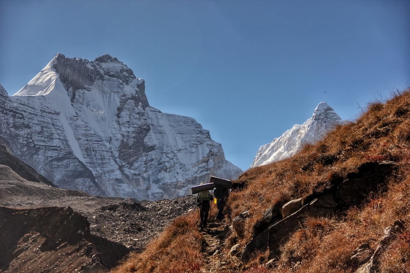
Visit the sacred shrine of Gangotri in the morning, also buy all the necessary items from the market. Cross the bridge over Bhagirathi River and start the climb on the right. First few kilometres of the trek are very steep so try to walk with a slow yet constant speed. The trail initially passes through pine trees then enters a mix vegetation zone of fir and bhoj trees. While trekking you’ll see Kedar Ganga flowing on your left, deep down in the gorge. The cascading sound of the furious river and the whispering sound of trees are a treat to ears.
Soon you’ll witness the first glimpse of Thalaysagar and every step will take you closer to this mystical mountain. Just before reaching Bhoj Kharak there is a steep and slant rock amidst the trail with space of just a few steps, it is also known as Spider Wall amongst trekkers. But while it may seem daunting in the pictures, it is not that difficult to traverse this section in the absence of snow. During early June or late October if the rocky face is covered with snow then it will require some skills to cross this section because one slip can drag you to few hundred feets below. Cross this section and you’ll reach Bhoj Kharak.
Situated at the elevation of 3,780mts above sea level Bhoj Kharak is a small and an average looking campsite. If you are fit and managed to reach Bhoj Kharak at around noon then try to push and reach Lower Kedar Kharak on the same day.
Day 3
Bhoj Kharak – Kedar Kharak: Trek 5 Kms
This 5kms stretch passes through some patches of complicated rugged terrains. After every half an hour into the trek you’ll see a pleasant change in the scenery. Initially it starts with a flora rich trail with numerous Bhojpatra trees and colourful wild bushes around. Soon the view changes with Manda peaks revealing itself.
Stunning views of Bhrigupanth peak will also catch up as you trek nearer to Kedar Kharak. Concentrate on every step while you cross the land sliding zone of Gila Pahar. If this section of Gila Pahar is in very bad shape then try and trek down all the way to Kedar Ganga, cross the river and hike against the river flow until you cross the Gila Pahar intersection then cross the river again and hike back to the original trail that leads to Kedar Kharak.
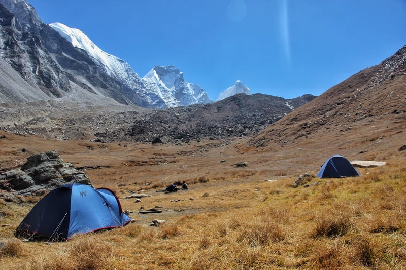
A wide valley opens up as you proceed towards Lower Kedar Kharak (4100mts) and the trek ends up at the beautiful meadow of Kedar Kharak situated at an elevation of 4,280mts above sea level. Even though this trekking stretch is just 5kms long, it demands good physical strength and endurance from trekkers. But in the end it is a well paid off effort because Kedar Kharak is one of the most beautiful campsites in the Gangotri National Park region. Also, Bharal (Blue Sheep) often visit here for grazing, making it a picture perfect location for photographers. The sight of Bhrigupanth and Thalaysagar peaks standing high together is like a surreal dream.
Day 4
Kedar Kharak – Kedar Tal – Jogin ABC – Kedar Tal: Trek 10 Km
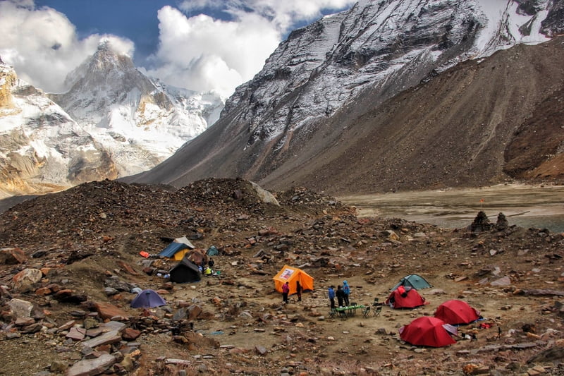
It takes another 5kms to reach Kedar Tal from Kedar Kharak and most of the route is on moraines and glacier covered with moraines. If trekking in June you might have to trek on snow for last couple of kilometres before Kedartal. Cross the brook carrying icy cold water and climb the steep rocky terrain. Keep following the cairn markings to ensure that you are on the right trail.
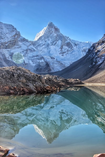
After climbing the final ridge, Kedar Bamak Glacier comes in the view along with its glacial lakes. The foot of Mt. Bhrigupanth and Mt. Thalaysagar merges with the Kedar Bamak Glacier. An hour further into the trek reveals a beautiful high altitude lake, the immaculate Kedar Tal. The view of Thalaysagar peak reflecting on the still water of Kedartal is mesmerizing.
Kedar Tal is situated at an altitude of 4780mts above sea level. AMS is quite common at such altitude so it is better to go for an acclimatization hike. Exploring Jogin Advance Base Camp is the best possible option. Leave from Kedartal at around noon and trek towards Jogin ABC (4900mts). This hiking stretch will not only get you well acclimatized but it will also showcase the best views of Thalaysagar peak, its West Ridge will open up and you’ll see the Thalaysagar Icefall from near. Also Jogin group of peaks will reveal itself. Trek back to Kedar Tal. Overnight in tents.
Day 5
Kedar Tal – Gangotri: Trek 18 Kms
Wake up early in the morning for a glorious sunrise and absorb as much beauty as you can. It is one long and tiring hike back to Gangotri this day which takes around 7-8hrs to complete. If you manage to reach Bhoj Kharak by 3pm then proceed towards Gangotri, else camp at Bhoj Kharak.
Day 6
Gangotri – Uttarkashi – Dehradun: Drive 258 Kms, 10 hrs
Drive back to Dehradun
Users
average
Last update: Ankit karki
(11 May 2020)