Route
verified

Chamonix to Zermatt, Alps

Mountain: Mont Blanc (4 810 m / 15 781 ft), Matterhorn (4 478 m / 14 692 ft), Pigne d'Arolla (3 796 m / 12 454 ft)
Activity type: Backcountry Skiing
Activity level: Challenging
Elevation: 3 000 m / 9 843 ft
Duration: 6 Day(s)
Expenses: from$ 2 000
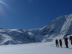
Image of Chamonix to Zermatt, Alps
Credit: www.alpineaddiction.no

Overview

Route Name:
Chamonix to Zermatt, Haute Route Ski Tour
Activity type:
Backcountry Skiing
Activity level:
Challenging
Type of Climb:
Snow
Location:
Europe, France, Switzerland
Starting Point:
Parent Range:
Mountain:
First Ascent: Please update
Duration:
6 Day(s)
Max. Elevation:
3 000m / 9 843 ft
Vertical Gain:
5 100m / 16 732 ft
Length:
120km / 75 miles
Climbing Season(s):
01 Mar-15 May;
Nearst
Airport(s):
Convenience Center(s):
National
Park(s):
Please update

Location

Europe, France, Switzerland
  • Your Chance To Edit •  Add / Share you knowledge with mates

    The Haute Route, the High Route between Chamonix (France) and Zermatt (Switzerland) is "the mother" of all ski touring traverses. From Europe's tallest mountain, the Mont Blanc to the Matterhorn, this route leads along some of the most exciting mountain scenery to be found anywhere. After spending a week in the winter backcountry of the Western Alps walking down Zermatt's bustling main street will feel like returning into a different world.
  • Description Edit •  Add / Share you knowledge with mates

    There are two variations for the Haute Route Ski Traverse. Both trips take 6 days, but differ for the duration of 2 full and 2 half days starting on day 3. 1) Verbier Variation: "The Regular Route": Most commonly done variation, stays north of the divide of the Alps in terrain less committing in terms of avalanche hazard and involves less technical difficulty and shorter days. On Day 3, the use of the gondola in Verbier makes gaining altitude easy. Total vertical gain is up to 5100 m = 16700 ft climb, descent is up to 8 360 m = 27 420 ft. The total length of the descent is over 73.5 km = 46 miles 2) Valsorey Variation: "The Classic Route": Less popular nowadays, uses smaller huts and the route sticks closer (and south) to the divide of the Western Alps with more glacier travel than the "Regular", more vertical and longer days. This variation is suitable later in the season, when snow conditions is more stable. No lift assistance.The ability to safely front point up a 40 degree snow slope without a rope belay while carrying skis on your pack is required when climbing from the Valsorey Hut to the Plateau de Couloir on Day 5. Total vertical gain is about 6000 m = 19430 ft, descent is up to 7600 m = 25000 ft. The total length of the descent is over 77 km = 48 miles.
  • Getting There Edit •  Add / Share you knowledge with mates

    The beginning of the route is located about 15 minutes up-valley from Chamonix. The nearest international airports is Geneva.
  • Are You Ready? Edit •  Add / Share you knowledge with mates

    Strenuous backcountry ski tour in alpine, mostly glaciated terrain on alpine touring or sturdy telemark equipment. You must be able to ski safely and controlled at all times while wearing a mid-weight backpack (7-10 kg /15 lb-22 lb). Depending on the conditions, you might have to rope on while skiing both up and downhill. You need to be in very good physical and mental condition, ready to be on your feet for about 8 - 10 hrs including, steep, continuous uphill climbs of up to 1200 meters (4100 ft) on some of the days. Being on your feet every day for 7 days requires a good deal of stamina.
  • Tips Edit •  Add / Share you knowledge with mates

    Cellular Network: Yes (Accomodation)

    Mobile Internet: Yes


    In case of bad weather or poor route condition the normal itinerary may be changed - you can skip a day or two by using public transport and get back on track in either Verbier, Bourg St. Pierre, Evolene or Champex, depending on the preliminary itinerary. To give an estimate, about 80% of our Haute Route trips run in accordance with the schedule and in about 20% itinerary changes are necessary, more often due to lack of fitness than weather and avalanche hazard issues.

  • Parameters Edit •  Add / Share you knowledge with mates

    Base Camp Elevation: Please update
    Summit Camp Elevation: Please update
    Accommodation in Base Camp: Please update
    Accommodation above Base Camp: Please update
    Number of Camps: Please update
    Avg. Cost: 2 000 USD
    Age Restrictions: Please update
    Soloing: Please update
    Descent Route: Same
    Specify descent time: Please update
  • Key Points Edit •  Add / Share you knowledge with mates

    Name (Elevation) Description
  • Agencies Edit •  Add / Share you knowledge with mates

    Guided Tours
  • GPS-Tracks

    Haute_Route.gpx
    gps-avatar
    Mountain Planet
    344 download(s)
    Add
  • Did You Know Edit •  Add / Share you knowledge with mates

  • References Edit •  Add / Share you knowledge with mates

Last update: (10 Feb 2016) • History
No one has been added yet

0 climber who were here

Day 1

Descent to the Argentiere Glacier.
Early morning start from Argentiere village. Gondola to the Grand Montet (3300 m) and descent to the Argentiere Glacier (about 2700 m) then traverse across the glacier to the Argentiere Hut (2770 m=9085 ft). Vertical gain is 170 m = 560ft, descent is 650 m = 2130 ft, total length is 4 km, 2.5 hrs. Night in the Hut.

Read more
Day 2

Champex Village.
Early morning departure. Short run down the Argentiere Glacier, then up the Col de Passon (3028 m), towards the top often crampons required. Short descent underneath the Aiguille du Chardonnet north face and skin across the Tour Glacier and up to the Col Superieur du Tour (3289 m), which marks the border to Switzerland. A long descent across the Trient glacier, followed by a short climb to the Col des Ecandies (2 796 m) opens up a magnificent run into Val d'Arpette, and the quaint village of Champex (1480 m). Lodging in town. Vertical gain is 1020 m = 3345 ft, descent is 2345 m = 7692 ft.

Read more
Day 3

Prafleuri Hut.
Taxi ride to Verbier (1 hr). Gondola ride and descent in the Verbier Ski resort. Climb to the Col de la Chaux (2940 m), short descent and another climb to Col de Momin (3003 m). Optional ski ascent of the Rosablanche (3336 m) and beautiful ski run to the Prafleuri Hut (2662 m) - showers available. Vertical gain is 900 m = 2950 ft, total descent is 900 m = 2950 ft not counting the descent in the Verbier resort.

Read more
Day 4

Dix Hut.
Short climb to the Col du Roux, short descent and then follows a long level traverse above the Dix Lake. After about 2.5 hrs, climb up to the Pas du Chat and on to the Dix Hut (2990m = 9800ft), probably the nicest of all huts along the Haute Route in spectacular setting. Vertical gain is 800 m = 2620 ft, descent is 350 m = 1150 ft, total length is 9 km, up to 5 hrs. In the afternoon, optional ascent of La Luette, an easy ski touring peak with good views above the hut with a light pack.

Read more
Day 5

Vignette Hut.
Spectacular climb through the rugged glacier to the Pigne D'Arolla 3800m and descent to the Vignette Hut (3157m = 10360 ft), vertical gain is 900 m = 2950 ft, descent is 640m = 1340' decent, total length is 7km, up to 6 hrs.

Read more
Day 6

Arriving to Zermatt.
Today waits the famous Three-Col-Traverse with Matterhorn view, probably the best day of the whole trip! Via Col de l'Eveque (3392m), Col de Mont Brulee (3213m) and Col de Valpelline (3568m) and a long, glaciated descent underneath the impressive North Face of the Matterhorn all the way into Zermatt. Vertical gain is 1120 m = 3675 ft, descent is 2670 m = 8760 ft, total length 25 km, up to 8 hrs.

Read more
Sort by:

show:

  • 6
  • 18
  • 36

Join the growing Alpine Community now.