Route
verified

Annapurna Base Camp Trek, Himalaya

Mountain: Annapurna (8 091 m / 26 545 ft)
Activity type: Hiking
Activity level: Moderate
Elevation: 4 130 m / 13 550 ft
Duration: 8 Day(s)
Expenses: from$ 1 000
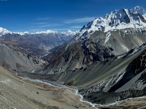
Image of Annapurna Base Camp Trek, Himalaya
Credit: www.spirin-foto.livejournal.com

Overview

Route Name:
Annapurna Base Camp Trek, Трек к ABC, ABC Trek, Trek to ABC, Trek to Annapurna Base Camp, Annapurna Sanctuary, Треккинг в Базовый Лагерь Аннапурны
Activity type:
Hiking
Activity level:
Moderate
Type of Climb:
Trekking
Location:
Asia, Nepal: (Western Region)
Starting Point:
Parent Range:
Mountain:
First Ascent:
1/1/2015
Duration:
8 Day(s)
Max. Elevation:
4 130m / 13 550 ft
Vertical Gain:
3 060m / 10 039 ft
Length:
80km / 50 miles
Climbing Season(s):
01 Sep-30 Nov;
01 Mar-30 Jun;
Nearst
Airport(s):
Convenience Center(s):
National
Park(s):

Location

Asia, Nepal: (Western Region)
Guided Tour

Location: Nepal

Price: $0
10 Day(s)

Activity type:Hiking

Difficulty: Moderate/ Challenging

0 reviews
Add to wishlist
Guided Tour

Location: Nepal

Price: $0
12 Day(s)

Activity type:Hiking

Difficulty: Moderate/ Challenging

0 reviews
Add to wishlist
  • Your Chance To Edit •  Add / Share you knowledge with mates

    The Annapurna Base Camp trek is one of the most popular treks in the Annapurna region. The trail goes alongside terraced rice paddies, lush rhododendron forests, and high altitude landscapes, with the Annapurna Range in view most of the times. There are few treks that combine so many different landscapes and bring you so close to the base of 7,000 and 8,000 m high peaks in a such short period of time. The peaks of Hiunchuli, Annapurna South, Fang, Annapurna, Gangapurna, Annapurna III and Machhapuchre, are arranged almost precisely in a circle about 10 miles in diameter with a deep glacier-covered amphitheater at the center, where the Base Camp is set.
  • Description Edit •  Add / Share you knowledge with mates

    This route combines gentle walking along nice trails with steep ascendings and descendings by the stone steps. The distance is about 80 km (or 100 km if you also trek to the viewpoint Poon Hill). It takes 8-11 days. The altitude change is from 1000 m to 4130 m and back down. Overnight stays along all the route are in lodges. You can trek by yourself (and solo as well) or you can hire guide/porter. The weather in autumn and sring is sunny and warm (about 20 °C in the daytime), although the nights are cold and temperatures can fall to freezing. At the ABC it can fall to -15 °C in the night. It's also important thet weather can change rapidly and be unpredictable.
  • Getting There Edit •  Add / Share you knowledge with mates

    You can reach the starting point from Pokhara by bus or taxi.
  • Red Tape Edit •  Add / Share you knowledge with mates

    It's necessary to have Annapurna Conservation Area Entry Permit and TIMS Card. Entry Permit you can get in Kathmandu (Nepal Tourism Board, Bhrikutimandap, open hours 9 - 17), Pokhara (Nepal Tourism Board, Tourist Service Centre, Pardi Damside, open hours 10 - 17). You'll need 2 passport size photographs, a photo-copy of passport, form filled in, health insurance policy information. This Entry Permit is valid for single entry only and must be carried during the entire trip. Period of staying in the area is not defined. TIMS Card you can also get in NTB of Kathmandu and Pokhara. You'll need 2 passport size photographs and a photo-copy of passport. You have to pay fees for both Entry Permit and TIMS Card.
  • Are You Ready? Edit •  Add / Share you knowledge with mates

    This trek is suitable for any walker. It does not require super fit or any previous trekking/mountaineering experience. If you are healthy and can walk 5 to 6 hours daily, you can do this trekking. However, daily jugging or walking exercise is useful before you depart.
  • Tips Edit •  Add / Share you knowledge with mates

    Cellular Network: Yes (Logistics)

    Mobile Internet: Yes (There is cell coverage along the route, but not everywhere. There can be 2-3 days without network. You can buy sim-card of local companies Mera Mobile or NCell.)


    The trail goes up and down several times on the route. One should be prepared for long ups and downs by the stone steps. Lodges are situated rather close to each other, so that you can stop earlier in case of bad weather. Between Bagar and Machapucchre Base Camp there can be a risk of avalanches, make sure you inform yourself properly before setting off. In the area of Annapurna Sanctuary the trail can be snowy.

  • Parameters Edit •  Add / Share you knowledge with mates

    Base Camp Elevation: 1 070 m / 3 511 ft
    Summit Camp Elevation: Please update
    Accommodation in Base Camp: Both - huts and tents
    Accommodation above Base Camp: Huts only
    Number of Camps: 7
    Avg. Cost: 1 000 USD
    Age Restrictions: 14
    Soloing: Yes
    Descent Route: Another Route -Please update
    Specify descent time: 3 Day(s)
  • Key Points Edit •  Add / Share you knowledge with mates

    Name (Elevation) Description
    Naya Pul
    1 070 m / 3 511 tf
    This is the starting point of the route, where to buses or taxis from Pokhara arrive. You can go further by taxi or jeep if you want to avoid few hours walk along the road.
    Ghandruk
    1 940 m / 6 365 tf
    This is a beautiful village mostly inhabited by the Gurung community. There are Gompa and the Gurung Museum. You can also enjoy the stunningly close-up towering views of Fishtail, Annaurna South, and Hinchuli mountains.
    Chomrong
    2 170 m / 7 119 tf
    This is a beautiful village locates on the slope. It's population is mostly Gurung as well.
    Bamboo
    2 310 m / 7 579 tf
    Bamboo lodges are surrounded by bamboo and rhododendron forest.
    Himalaya
    2 840 m / 9 318 tf
    The lodges here offer very basic comfort.
    Deurali
    3 230 m / 10 597 tf
    Lodges here cling to a rocky cliff side in the shadow of Fishtail.
    Machhapuchre Base Camp
    3 700 m / 12 139 tf
    This is several stone houses, where you can have a lunch or stay overnight.
    Annapurna Base Camp
    4 130 m / 13 550 tf
    There several stone houses here that are surrounded by glaciers, stone walls and snowy summits. At the sunsets lanscapes are specially beautiful.
    Jhinu Danda
    1 760 m / 5 774 tf
    There are hot springs baths at the bank of the river a little bellow the village.
    Phedi
    1 130 m / 3 707 tf
    From this possible end point you can go to Pokhara by bus or taxi.
  • Agencies Edit •  Add / Share you knowledge with mates

    Guided Tours
  • GPS-Tracks

    Annapurna_BC.gpx
    gps-avatar
    Mountain Planet
    384 download(s)
    Add
  • Did You Know Edit •  Add / Share you knowledge with mates

    Trek to ABC will lead you to the heart of massif Annapurna. The highest peak of it is Annapurna I (8091 m) is the first peak over 8000 m that was conquered. In 1950 Maurice Herzog and Louis Lachenal of a French expedition reached the summit. However, this wasn't the first time to reach such an altitude. In   ... Read more
  • References Edit •  Add / Share you knowledge with mates

Last update: (05 Jul 2018) • History
Viktoriia Vitova

 Viktoriia Vitova 

36 years, Ukraine

Guide

5330

Mountaineering, Hiking, Rock Climbing
Add to wishlist

2 climber who were here

Day 1


Naya Pul - Ghandruk. First few hours from Naya Pul you walk along the road. Then there is a nice trail, that goes up slowly till Syauli Bazar, after which there are stone steps uphill. After the steps there is a gentle walk to Ghandruk.

Read more
Day 2


Ghandruk - Chomrong. At this juncture, we climb up for around an hour up to Kimrong Danda. Next, a steep descent takes us to the Kimrong Khola. After another steep ascent from Kimrong Khola to Chere Danda, we descend for a while, then it’s a gentle walk to Chomrong.

Read more
Day 3


Chomrong - Bamboo. The trail out of Chomrong descends via 2500 stone steps and crosses the Chomrong Kola on a suspension bridge. It is an uphill climb to Sinuwa. Next, an easy downhill trail leads to Bamboo, descending almost till the river Modi Kola.

Read more
Day 4


Bamboo - Deurali. The trail goes through the bamboo forest which is damp and cold, then ascends steadily with fewer steep sections. After reaching Himalaya Hotel the forest opens up. It is a steep climb up to Hinku Cave. From here the trail drops closer to the river before climbing again to Deurali.

Read more
Day 5


Deurali - Machhapuchhre Base Camp - Annapurna Base Camp. The path climbs gently. On the trek from Bagar to Machhapuchhre Base Camp avalanche tracks can make walking less comfortable. From Machhapuchre Base Camp the trail turns from the valley of Modi Kola to the Sanctuary. The vegetation disappears. The path widens. We follow the stream and then climb to a few huts alongside the moraine.

Read more
Day 6


Annapurna Base Camp - Bamboo. There is a viewpoint above ABC on the slopes of the South Annapurna. One can see splendid views from there at the sunrise. Then there is trek downhill to Bamboo by the same route, as the way up.

Read more
Day 7


Bamboo - Jhinu Danda. From Bamboo, it is an uphill trek to Kuldighar followed by a downhill walk to Chhomrong Khola. Then we climb the stone steps to Chhomrong. From Chhomrong there are numerous possibilities for the return to Pokhara. One of them is to descend to Jhinu Danda. The hot springs are just 15-20 minute downhill walk from Jhinu Danda.

Read more
Day 8


Jhinu Danda - Naya Pul / Phedi. Trek to Naya Pul or Phedi from Jhinu Danda takes about 7 hours.

Read more
Sort by:

show:

  • 6
  • 18
  • 36

Join the growing Alpine Community now.