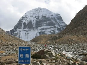
Mount Kailash Trek, Tibetan Plateau
| Mountain: | Mount Kailash (6 638 m / 21 778 ft) |
| Activity type: | Hiking |
| Activity level: | Moderate |
| Elevation: | 5 630 m / 18 471 ft |
| Duration: | 3 Day(s) |
| Expenses: | from$ 2 000 |
Overview
| Route Name: |
Mount Kailash Trek, Kora around the Mt. Kailash, Mt. Kailash Parikrama, Кора вокруг горы Кайлаш, Парикрама вокруг горы Кайлаш, Kora, Cora, Кора, Треккинг вокруг Кайлаша |
| Activity type: |
Hiking |
| Activity level: |
Moderate |
| Type of Climb: |
Trekking |
| Location: |
Asia, China: (Tibet Autonomous Region) |
| Starting Point: | |
| Parent Range: | |
| Mountain: | |
| First Ascent: |
1/1/2015 |
| Duration: |
3 Day(s) |
| Max. Elevation: |
5 630m / 18 471 ft |
| Vertical Gain: |
1 000m / 3 281 ft |
| Length: |
56km / 35 miles |
| Climbing Season(s): |
01 Apr-31 Oct; |
| Nearst Airport(s): |
|
| Convenience Center(s): | |
| National Park(s): |
Please update |
0 climber who were here
The Kailash kora usually begins on the western edge of Darchen. Only 4km from Darchen the trail climbs up over the southwest end of a east–west ridge to reach a cairn at 4730m. The cairn is bedecked with prayer flags and marks the first views of Mt Kailash’s southern. Very quickly the trail bends round to the north and enters the barren Lha-chu Valley. From here on, the narrow Lha-chu River provides a steady supply of water all the way to Dira-puk Monastery. After passing a series of ruined chörtens and a number of long mani (prayer) walls, the trail reaches a small bridge across the Lha-chu at 4710m. The bridge is about three hours’ walk from Darchen and is directly below Chuku Monastery perched high above the valley floor on the hillside to the west. During the pilgrim season, a few nomad tents may be set up on the other side of the river from the monastery, with food (instant noodles and snacks) and water for sale. From the Chuku bridge there are alternative trails along the east and west banks of the river. The trail along the eastern bank is the regular pilgrim route, but on the western trail there are some fine grassy camp sites at Damding Donkhang (4890m). Either way it’s about three hours to Dira-puk Monastery, where is another bridge. From this point you can see the northern side of Mt. Kailash and can walk towards the mount up to the Kangkyam Glacier.
From Dirapuk Monastery the trail goes on the east bank of the river and in two hours reaches a rocky expanse of Shivatsal (5330m). There's plenty of stone cairns draped with items of clothing. About 30 minutes from Shivatsal the trail turns eastward for the completion of the ascent to the highest point of this route - 5630m Drolma La Pass. There's Gauri Kund Lake right under the pass on its east side. Descent from Domla La Pass to the grassy banks of the Lham-chu Khir is long and very steep and takes approximately an hour. In the valley there are two routes that follow both sides of the river. The eastern-bank trail presents better views and there’s less marshy ground but it requires crossing the river by boulder hopping. About three hours on, grassy fields appear alongside the river affording those with tents endless spots to set up camp. An hour or so from the start of the camping fields is the Zutulpuk Monastery (4790m).
From the Zutulpuk Monastery, the trail follows the river closely for an hour or so, then climbs above the river and enters a narrow canyon. When the trail emerges onto the Barkha plain, it’s now an easy one-hour walk back to Darchen along a dirt road.
show:
- 6
- 18
- 36
|
Availability
|

