Route
verified

Whymper Route, Chimborazo (6 310 m / 20 702 ft)

Mountain: Chimborazo (6 310 m / 20 702 ft)
Activity type: Mountaineering
Activity level: Challenging
Elevation: 5 030 m / 16 503 ft
Duration: 16 Hour(s)
Expenses: from$ 3 000

Overview

Route Name:
Whymper Route, Original Route, Классический Маршрут, Маршрут Уимпера
Activity type:
Mountaineering
Activity level:
Challenging
Type of Climb:
Snow & Ice
Location:
South America, Ecuador: (Provincia del Chimborazo)
Starting Point:
Parent Range:
Mountain:
First Ascent:
4/1/1880 Edward Whymper (England), Louis Carrel (Italy), Jean-Antoine Carrel (Italy)
Duration:
16 Hour(s)
Max. Elevation:
5 030m / 16 503 ft
Vertical Gain:
1 280m / 4 199 ft
Length:
6km / 4 miles
Climbing Season(s):
15 Nov-28 Feb;
01 Jun-31 Aug;
Nearst
Airport(s):
Please update
Convenience Center(s):
National
Park(s):

Location

South America, Ecuador: (Provincia del Chimborazo)
  • Your Chance To Edit •  Add / Share you knowledge with mates

    Chimborazo will always be a special mountain because its summit, along with summit of Everest, tops the list of the "most-most" world's mountains. No doubt that Everest is the highest mountain of the world but Chimborazo holds a top position in the list of the farthest points of the Earth's center. Climbing Chimborazo requires good physical conditions, excellent acclimatization and cramponing skill and it is one of the "classic" one-day-ascent along with the Mont Blanc and the Matterhorn. In addition, a trip to Ecuador will allow you to combine Chimborazo with ascents to other distinguished volcanoes such as Cotopaxi or Antisana. Well, fans of diving at the most remote parts of our planet can go to the Galapagos after the climbing as well.
  • Description Edit •  Add / Share you knowledge with mates

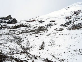
    The Whymper Route (to the far right as you leave the hut) used to be the usual approach to the summit, but after some deaths on the icy traverse below the seracs, it is rare used. Route begins from the Whymper Refuge and follows in northeast direction aiming to the well-recognized gap in the rocky belt. The climb goes on a steep snow and ice slope till the seracs and crevasses at the point of 5700 meters. Then you are to traverse left towards to the volcano's dome and further leading via the Veintemilla summit to the main (Whymper) summit. From here to the main summit of Chimborazo is still about an hour way.
  • Getting There Edit •  Add / Share you knowledge with mates

    From the capital city Quito to Riobamba by car or by bus and from there to the entrance of the "Chimborazo Reserve". Then you have to drive to the parking lot near the Carrel Refuge located at 4850 meters. Usually same day climbers go further to the Whymper Refuge (5030 meters, apx. 30-40 minutes) where they spend an overnight before summit push.
  • Red Tape Edit •  Add / Share you knowledge with mates

    Since the end of 2012 climbing all the volcanoes of Ecuador are not allowed without hiring an accredited local mountain guides. There is a lot of travel agencies in Quito that can help you with the organization of the climb.
  • Are You Ready? Edit •  Add / Share you knowledge with mates

    Requirements to your mountaineering skills and fitness are strongly depend on the route's conditions. If there is no snow on the mountain, you'll climb for hours on steep ice slopes that may require front-pointing on the steepest sections. For safety it is necessary to organize the belay points (ice screws), that can definitely takes additional time. All the way you should be roped up. The descent on the steep ice slopes is also a difficult challenge and makes high demands on your cramponing skill. Perfect condition of the route it is when the slopes of the volcano are covered with a small amount of dense snow - climbing gets much easier and safer, the organization of belay points is usually not required. If there are a lot of loose snow on the slopes, then the climb can also be difficult, and there is a real threat of avalanches. Pay extra attention to your acclimatization - overnight stay at an altitude of 5030 meters, as well as reaching the summit of 6310 meters are possible only if you have an excellent acclimatization. The acclimatization process usually takes 6-8 days. As a rule, before Cotopaxi climbers do an ascent to the Illiniza Norte and Cotopaxi.
  • Tips Edit •  Add / Share you knowledge with mates

    Cellular Network: No


    Whymper Route is a bit shorter than the "Normal Route" located on the western ridge of the Chimborazo. Its climbing in last recent years became more complicated due to the threat of seracs collapse in its upper part. You better leave Whymper Refuge before midnight to climb the most dangerous part of the route in the coldest time of the day. Try to reach the summit with the sunrise and begin the descent in the morning. Usually Chimborazo is covered by clouds after noon and it might be hard to find the right descent trail on the wide snow and ice ridge.

  • Parameters Edit •  Add / Share you knowledge with mates

    Base Camp Elevation: 5 000 m / 16 404 ft
    Summit Camp Elevation: Please update
    Accommodation in Base Camp: Tents only
    Accommodation above Base Camp: Both - huts and tents
    Number of Camps: Please update
    Avg. Cost: 3 000 USD
    Age Restrictions: At least 21 years old
    Soloing: No, at least 0 people
    Descent Route: Another Route -Please update
    Specify descent time: 5 Hour(s)
  • Key Points Edit •  Add / Share you knowledge with mates

    Name (Elevation) Description
    Refuge Carrel
    4 850 m / 15 912 tf
    Big mountain hut located near the parking lot. Can accommodate up to 50 people.
    Refuge Whymper
    5 030 m / 16 503 tf
    Mountain hut located in 30 minutes walking distance upper the parking lot. It provides up to 50 bunk-beds.
    Veintimilla Summit
    6 268 m / 20 564 tf
    One of the two highest volcano's summits. The most part of the climbers start their descent after reaching this point due to the threat of crevasses on the route to the Whymper (Main) Summit.
    Whymper Summit
    6 310 m / 20 702 tf
    The highest (Main) summit of Chimborazo.
  • Agencies Edit •  Add / Share you knowledge with mates

  • GPS-Tracks

    Add
  • Did You Know Edit •  Add / Share you knowledge with mates

    In 1880 Chimborazo's summit was first climbed by Edward Whymper and the brothers Louis and Jean-Antoine Carrel. As there were many critics who doubted that Whymper had reached the summit, later in the same year he climbed to the summit again choosing a different route (Pogyos) with the Ecuadorians David   ... Read more
  • References Edit •  Add / Share you knowledge with mates

Last update: Peter J. Boogaard (19 Jul 2018) • History
No one has been added yet

1 climber who were here

Hour 1


You will depart from the Whymper Refuge at midnight and continue on the northeast direction leading to the well recognizable gap in the rocky belt on the western ridge. Following the steep snow and ice slope you will reach the Veintimilla Summit in 5-6 hours. Then you will traverse across to the Whymper summit, the furthest point from the center of the Earth. The ascent will take up to 10 hours approximately and usually climbers descend to the Refuge in four-five hours.

Read more
Sort by:

show:

  • 6
  • 18
  • 36

Join the growing Alpine Community now.