Route
verified

Southeast Ridge, Iliniza (5 263 m / 17 267 ft)

Mountain: Iliniza (5 263 m / 17 267 ft)
Activity type: Mountaineering
Activity level: Easy/ Moderate
Elevation: 4 700 m / 15 420 ft
Duration: 2 Day(s)
Expenses: from$ 500

Overview

Route Name:
Southeast Ridge, Normal Route, Ruta Normale, Стандартный Маршрут, Юго-Восточное Ребро
Activity type:
Mountaineering
Activity level:
Easy/ Moderate
Type of Climb:
Rock
Location:
South America, Ecuador: (Provincia de Pichincha)
Starting Point:
Parent Range:
Mountain:
First Ascent:
1/1/2015
Duration:
2 Day(s)
Max. Elevation:
4 700m / 15 420 ft
Vertical Gain:
1 226m / 4 022 ft
Length:
11km / 7 miles
Climbing Season(s): Please update
Nearst
Airport(s):
Convenience Center(s):
National
Park(s):

Location

South America, Ecuador: (Provincia de Pichincha)
  • Your Chance To Edit •  Add / Share you knowledge with mates

    Ascent to the North Summit of Iliniza unofficially holds the first place in popularity among all ascents to Ecuadorian volcanoes. The normal route via the southeast ridge does not require any mountaineering skills and provides the easy climb to the mountain summit raised above 5000 meters. By the way you will get the new experience of having an overnight in the refuge located at 4700 meters above sea level. As a rule climbers come to Iliniza to get good acclimatization needed for climbing taller volcanoes such as Chimborazo and Cotopaxi.
  • Description Edit •  Add / Share you knowledge with mates

    The Southeast Ridge route to Iliniza North does not require any climbing skills and can be done anybody who has a good physical fitness. The climb usually takes 2 days. The route starts from the parking lot "La Virgen" located at 3900 meters near the El Chaipi city. Approach from the parking lot to the Iliniza Refuge (Nuevos Horizontes Hut) takes up to the 3-5 hours. The refuge is situated at the 4700 meters on the wide saddle between South and North summits. To carry your loads from the parking lot to the refuge you can hire porters or horses. Depending on the route condition the climb may require some climbing equipment such as a harness, rope and carabiners, but in general above the refuge route goes on gentle rocky slopes of south-eastern ridge. Rocks here are very loose so be extremely careful and always keep an eye on the groups that are above you cause they may accidentally pull on you a rockfall. The helmet is obligatory throughout the summit day and descent.
  • Getting There Edit •  Add / Share you knowledge with mates

    From Quito by bus or car to the city El Chaupi and then proceed to the La Virgen parking lot located at 3900 meters in Illinizas Ecological Reserve.
  • Red Tape Edit •  Add / Share you knowledge with mates

    Since the end of 2012 climbing all the volcanoes of Ecuador are not allowed without hiring an accredited local mountain guides. There is a lot of travel agencies in Quito that can help you with the organization of the climb.
  • Are You Ready? Edit •  Add / Share you knowledge with mates

    Pay extra attention to your acclimatization - overnight stay at an altitude of 4700 meters, as well as reaching the summit of 5126 meters are possible only if you have an excellent acclimatization. The acclimatization process usually takes 3-4 days. As a rule, before Iliniza climbers do an ascent to the peak Pasachoa.
  • Tips Edit •  Add / Share you knowledge with mates

    Cellular Network: Yes (Accomodation)

    Mobile Internet: Yes (Due to the fact of proximity to the capital city and other surrounding cities, cellular network covers the most part of the route.)


    To deliver your stuff from the parking lot to the refuge you can use porters or arrange horses. Weather is more stable during the night and in the morning, so climbers usually start climbing at 4 am. Rocks on the southeast ridge are very loose so be extremely careful and always keep an eye on the groups that are above you cause they may accidentally pull on you a rockfall. Put your helmets on when you reach the ridge. The couloir "Pass of Death" sometimes could be icy or snow covered and be difficult to climb. In some cases you may necessary to fix some ropes here. The descent can be done by the same route or you can use the "North Face" route which is safer and takes less time to reach the parking lot. Using "North Face" route for descent will force you to carry all your stuff to the summit or you need to organize its delivery down from the refuge.

  • Parameters Edit •  Add / Share you knowledge with mates

    Base Camp Elevation: 3 900 m / 12 795 ft
    Summit Camp Elevation: Please update
    Accommodation in Base Camp: Tents only
    Accommodation above Base Camp: Both - huts and tents
    Number of Camps: 1
    Avg. Cost: 500 USD
    Age Restrictions: At least 21 years old
    Soloing: No, at least 0 people
    Descent Route: Another Route -Please update
    Specify descent time: 5 Hour(s)
  • Key Points Edit •  Add / Share you knowledge with mates

    Name (Elevation) Description
    Parking lot "La Virgen"
    3 900 m / 12 795 tf
    The parking lot is located at 3900 meters in 9 km of the El Chaupi.
    Refuge "Iliniza"
    4 700 m / 15 420 tf
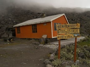
    Refuge is located on the wide scree saddle between North and South Ilinizas at 4700 meters. It can accommodate up to 25 people and has all facilities needed such as bunk-beds, toilet and kitchen. There is a small scree field near the refuge which can be used as a campground.
    El Paso de la Muerte (Pass of Death)
    5 050 m / 16 568 tf
    Steep scree couloir located on the summit ridge. Sometimes could be covered by ice and snow so you may need to fix some ropes here.
  • Agencies Edit •  Add / Share you knowledge with mates

    Guided Tours
  • GPS-Tracks

    Add
  • Did You Know Edit •  Add / Share you knowledge with mates

    Iliniza Norte unofficially holds the top position in popularity among all ascents to Ecuadorian volcanoes because it's actively used by climbers as a part of acclimatization preparation for the ascent to the higher volcanoes of Ecuador - Cotopaxi, Chimborazo and Kayambe. The normal route via the southeast   ... Read more
  • References Edit •  Add / Share you knowledge with mates

Last update: Slava Shevtsov (27 Jun 2018) • History
No one has been added yet

2 climber who were here

Day 1


The route starts from the parking lot "La Virgen", situated at 3900 meters in 9 kilometers from the El Chaupi. The first 3 km go through the alpine meadows on the well-recognized trail. Then you'll climb up a long scree slope, that will lead you in a 2-3 hours to the refuge "Ilinitza". The refuge is located on the wide saddle between North and South Ilinizas.

Read more
Day 2


Wake up early and be on route about 4 am. The trail to the southeast ridge could be well beaten depending on the climbing season. Always keep your way up unless you find a few steep sections to negotiate. You’ll get to the base of a false summit where you may need to make a traverse to the north. After traversing and going down a bit, you’ll find yourself at Paso de la Muerte (Pass of Death). This is a steep rocky gully that can be easily climbed with caution, especially if there’s some ice/snow on it. Keep traversing all the way north below the true summit which can be seen right above. A last steep gully should be climbed in order to access to the last short traverse, located a few meters below the summit, which is marked with an iron cross.

Read more
Sort by:

show:

  • 6
  • 18
  • 36

Join the growing Alpine Community now.