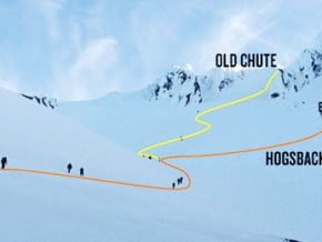
Route

South Side Normal Route, Mount Hood (3 429 m / 11 250 ft)

Mountain: Mount Hood (3 429 m / 11 250 ft)
Activity type: Mountaineering
Activity level: Easy/ Moderate
Elevation: 3 429 m / 11 250 ft
Duration: 9 Hour(s)
Expenses: from$ 700
Image of South Side Normal Route, Mount Hood (3 429 m / 11 250 ft)
Credit: www.mountainshop.net

Overview

Route Name:
South Side Normal Route, Hogsback Route
Activity type:
Mountaineering
Activity level:
Easy/ Moderate
Type of Climb:
Snow & Ice
Location:
North America, United States (USA): (Oregon)
Starting Point:
Parent Range:
Mountain:
First Ascent: Please update
Duration:
9 Hour(s)
Max. Elevation:
3 429m / 11 250 ft
Vertical Gain:
1 615m / 5 300 ft
Length:
13km / 8 miles
Climbing Season(s):
01 Apr-30 Jun;
Nearst
Airport(s):
Convenience Center(s):
National
Park(s):

Location

North America, United States (USA): (Oregon)
  • Your Chance To Edit •  Add / Share you knowledge with mates

    Mount Hood is Oregon's highest point and a prominent landmark visible up to 100 miles (160 km) away. It has convenient access and a minimum of technical climbing challenges. About 10,000 people attempt to climb Mount Hood each year. There are no trails to the summit. Even the "easier" southside climbing route is a technical climb with crevasses, falling rocks, and often inclement weather.
  • Description Edit •  Add / Share you knowledge with mates

    Start at the Timberline Lodge (5800 ft) and walk up on the right (east) side of the ski trails (there should be a special trail for climbers). Climb two miles to the top of the ski lift (8,600 ft), passing the Silcox Hut (7000 ft). At the top of the lift, head up the ridge toward Crater Rock. Go into the crater and pass Crater Rock on the right (east) side, staying to the left side of Devils Kitchen and Steel Cliff. Once past Crater Rock, take the snow ridge (known as Hogback, at 10,600 ft) up to the bergshrund. If you can't cross the bergshrund on a snowbridge, head around either side. From here, head up the snow chutes to the summit, taking the gully between the rock towers (Pearly Gates). The largest rockfall danger here is on the right (east) side of bergshrund (which is the route most people take) and before the Pearly Gates. You can get caught behind slow parties in the Pearly Gates, so as an alternative, you can head to the west side of the mountain after climbing the hogback, and eventually get to a snowfield you can hike up. Soon you will hit the summit ridge that you head east on until you reach the summit. This variation is longer, but might involve less waiting and is considered safer from rockfall.
  • Getting There Edit •  Add / Share you knowledge with mates

    Take Highway 26 east from Portland about 50 miles to Government Camp, OR. Just on the east side of town, turn left (north) at the sign for Timberline Lodge. Follow this road about 5 miles as it winds up the south side of the mountain to the lodge/ski area. Park in the lot.
  • Red Tape Edit •  Add / Share you knowledge with mates

    Climbing to the summit means entering the Mount Hood Wilderness Area which requires a free, non-quota, self-issued wilderness permit. These are available at the Timberline day lodge “Climbers’ Cave” and all trailheads within the wilderness area. The Climbers’ Cave does not have a door and is open year round, 24/7. The Climbers’ Cave does have bathroom facilities available to climbers.
  • Are You Ready? Edit •  Add / Share you knowledge with mates

  • Tips Edit •  Add / Share you knowledge with mates

    Cellular Network: No (Guided Tours)


    Since this route is on snow it sees changes from year-to-year. Some years the snow if more plentiful that others and the bergshrund can become less of an obstacle. Other years can allow ice to form in the Pearly Gates and cause that section of the route to become more exposed and might even require ice tools to ascend.

  • Parameters Edit •  Add / Share you knowledge with mates

    Base Camp Elevation: Please update
    Summit Camp Elevation: Please update
    Accommodation in Base Camp: Please update
    Accommodation above Base Camp: Please update
    Number of Camps: Please update
    Avg. Cost: 700 USD
    Age Restrictions: Please update
    Soloing: Please update
    Descent Route: Same
    Specify descent time: Please update
  • Key Points Edit •  Add / Share you knowledge with mates

    Name (Elevation) Description
  • Agencies Edit •  Add / Share you knowledge with mates

  • GPS-Tracks

    Add
  • Did You Know Edit •  Add / Share you knowledge with mates

  • References Edit •  Add / Share you knowledge with mates

Last update: Slava Shevtsov (26 Jun 2018) • History
No one has been added yet

0 climber who were here

Sort by:

show:

  • 6
  • 18
  • 36

Join the growing Alpine Community now.