Mountain

Mount Kahtadin (1 605 m / 5 267 ft)

Parent Range: N/D
Activity type: Mountaineering, Hiking, Backcountry Skiing
Summit(s): Katahdin-South Peak (5 269 m /17 287 feet), Pamola Peak (4 919 m /16 138 feet), Chimney Peak (4 900 m /16 076 feet), Hamlin Peak (4 756 m /15 604 feet), South Howe Peak (4 740 m /15 551 feet), North Howe Peak (4 700 m /15 420 feet)
Elevation: 1 605 m / 5 267 ft
Cost of climbing: N/D
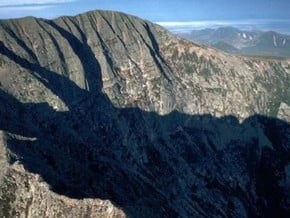
Image of Mount Kahtadin (1 605 m / 5 267 ft)
Credit: www.roadtrippers.com

Facts

Mountain Name(s):
Mount Kahtadin, Katahdin, Катадин,
Elevation:
1 605 m / 5 267 ft
Summit(s):
Katahdin-South Peak (5 269 m /17 287 feet), Pamola Peak (4 919 m /16 138 feet), Chimney Peak (4 900 m /16 076 feet), Hamlin Peak (4 756 m /15 604 feet), South Howe Peak (4 740 m /15 551 feet), North Howe Peak (4 700 m /15 420 feet)
Activity type:
Mountaineering, Hiking, Backcountry Skiing
Location:
North America, United States (USA): (Maine)
Starting Point:
Parent Range: Please update
Range:
First Ascent:
13/8/1804 Charles Turner Jr.
Geology:
Tectonic
Snow line: Please update
Prominence:
516 m / 1 693 ft
Isolation:
2 m / 1 ft
Climbing Season(s):
01 May-31 Oct;
Nearst
Airport(s):
Convenience Center(s):
National
Park(s):

Location

North America, United States (USA): (Maine)
  • Your Chance To Edit •  Add / Share you knowledge with mates

    Mount Katahdin is the highest mountain in the U.S. state of Maine at 5,267 feet (1,605 m). Named Katahdin by the Penobscot Indians, which means "The Greatest Mountain", Katahdin is the centerpiece of Baxter State Park. It is a steep, tall mountain formed from a granite intrusion weathered to the surface. The flora and fauna on the mountain are typical of those found in northern New England.
  • Description Edit •  Add / Share you knowledge with mates

    Mt. Katahdin has several trails leading up to either Pamola or Baxter Peak. There are two trails, Hunt and Abol, accessible from the south side of the mountain each having its own separate parking lot. These trails start right up the mountain, but each trail on the mountain ends up taking eight to ten hours depending on ability. The rest of the trails go up the north side or west side of the mountain. These are accessed from the Chimney Pond Trail. For these trails, hikers must park at the Roaring Brook Campground and hike in. All trails are maintained by the Baxter State Park Authority, who run the State Park. All of the trails on the mountain are classified as very strenuous, the highest classification the Park Authority gives, except for Saddle (strenuous), Hamlin Ridge trail (moderate), and Chimney Pond (moderate).
  • Listing Edit •  Add / Share you knowledge with mates

    • New England 4000-footers
    • New England Fifty Finest
    • U.S. State High Points
    • North America Isolated Peaks
  • Location Edit •  Add / Share you knowledge with mates

    Katahdin is the northern terminus of the Appalachian Trail, and is located near a stretch known as the Hundred-Mile Wilderness.
  • Getting There Edit •  Add / Share you knowledge with mates

    Take Interstate 95 to the Millinocket-Mattawamkeag exit about 50 miles north of Bangor, ME. Proceed to Millinocket, following the signs, then turn right where the road "T's" by a high school onto Katahdin Ave. Go a couple blocks and take a left at the sign for Baxter State Park. Follow that about 16 miles to the park.
  • Red Tape Edit •  Add / Share you knowledge with mates

    Baxter State Park is tightly controlled and the amount of people allowed to enter each day is regulated. Come early if you desire to climb the mountain (even 6AM is at some times too late!) or camp in one of the campgrounds at Katahdin's base.
  • Did You Know Edit •  Add / Share you knowledge with mates

  • Agencies Edit •  Add / Share you knowledge with mates

    Accomodation
    Guided Tours
  • References Edit •  Add / Share you knowledge with mates

Last update: Anastasia Pivnyuk (29 Nov 2016) • History

Other Mountains

Mountain

Location:North America, Canada:

Height: 0 m / 0 ft

Add to wishlist

Mountain

Location:Asia, Afghanistan:

Height: 3 541 m / 11 618 ft

Add to wishlist

Mountain

Location:North America, United States (USA):

Height: 2 870 m / 9 416 ft

Add to wishlist

Mountain

Location:Europe, Switzerland:

Height: 2 721 m / 8 927 ft

Add to wishlist
No one has been added yet

0 climber who were here

Sort by:

show:

  • 6
  • 18
  • 36

Join the growing Alpine Community now.