
 Chile")
Climbing Ojos del Salado (6893m) Chile
| Activity type: | Mountaineering |
| Activity level: | Moderate/ Challenging |
| Availability: |
21 Jan 2019 - 3 Feb 2019 |
| Duration: | 13 Day(s) / Tour with flexible start dates |
| Price: | from $2795 / Negotiable |
Full description
Climb the highest volcano in the world! Ojos del Salado lays in the southern part of the Atacama desert, During this trip we will come across places of beauty and
natural diversion in a high desert climate. From the summits we have 360 degree views beyond description.
We also climb two other mountains in the region, Siete Hermanos (4950m) and Volcano San Francisco (6018m) which will part of our acclimatization.
Price includes
- • Professional English speaking guide, Guide ratio 3:1 • Meals as mentioned, including drinks at camp meals (B – breakfast, L – Lunch, D – dinner) • Cook • Full private transport for all days • Full camp, includes: tents, kitchen equipment, chairs, tables, dinning tent etc • 2 night’s Hotel • 2 night’s Hostel (Laguna Santa Rosa) • Oxygen Bottle • First aid kit • Satellite phone • DIFROL climbing permit
Not included in price
- • Personal gear • Personal insurance • Drinks and meals in restaurant • Extra services not mentioned in the program • Tips
Guide
Verified Profile
- Email address
- Phone number
Jeff has had a lifelong passion for climbing and exploration of all sorts. Born in Australia he qualified as a mineralogist before realizing that climbing up rocks was much more interesting than digging down to look for them. (saying that, he still maintains a firm knowledge and interest in minerals). Jeff then made it his business to travel the world climbing challenging peaks from Pakistan to New Zealand, his experience leading him to work as a guide. He first arrived in South America in 1995 as a backpacker seeking adventure in the remote peaks and jungles of the continent. Strategically locating himself in Bolivia at the centre of the continent, Jeff has now made the country his home and the base of Climbing South America.
Location
Day 1
Copiapo Airport - Copiapo (400m)
Transfer to hotel, meeting with guide and question time.
45 mins drive, Hotel 3*
Day 2
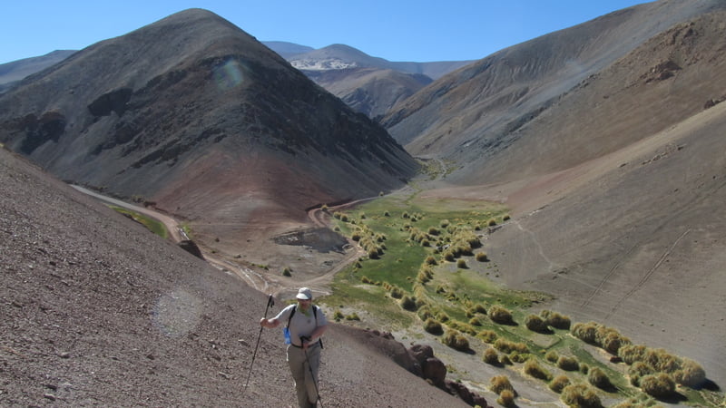
Copiapo - Valle Chico (3000m)
We leave Copiapo in the morning and head east, up the dry valleys. Scenery changes
from dry mountains to rivers in the lower valleys. Our camp is along the road in one
of the dry valleys. This first night is part of our acclimatizing before we head up to the
Altiplano.
3 - 4 hour drive (BLD) camping
Day 3
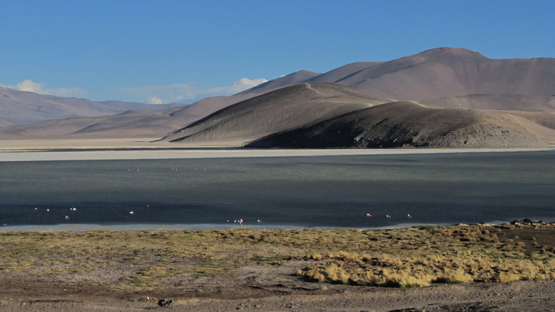
Valle Chico - Laguna Santa Rosa (3800m)
We make a short walk in the morning in the area, which is all part of our acclimatizing.
After lunch we pack up camp and drive to our second camp site. The road takes us to
the pass of, Portezuelo Maricunga, at 4125m above sea level. From the pass we head
down to Laguna Santa Rosa and Maricunga Salt Flat. Near the Laguna is a small hut
where we make our second camp, at 3800m. We are in the middle of the Chilean high
plateau, which is the most southern part of the Atacama Desert and the home of a very
diverse wildlife, such as flamingos and foxes. In the evening we can make a short walk,
where we have the chance see local flora and fauna where there is a large variety of
birds.
2 - 3 hour trek, 1 - 2 hour drive (BLD) hostel/camping
Day 4
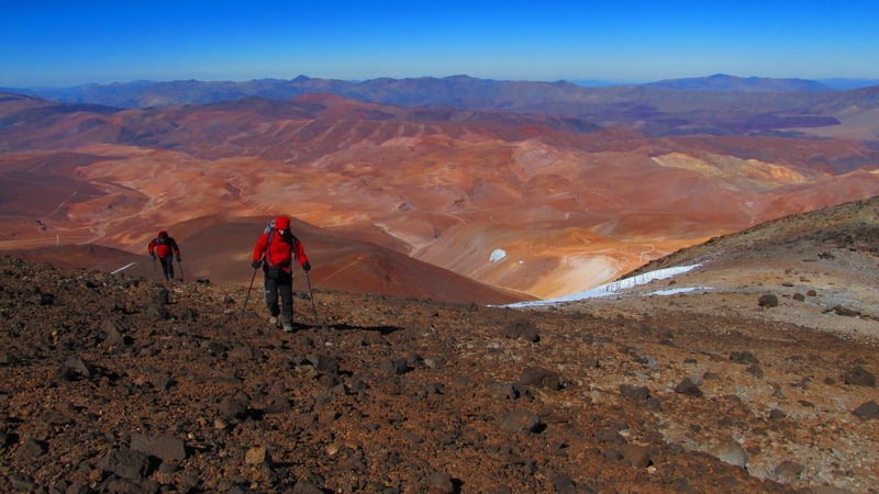
Laguna Santa Rosa - Siete Hermanos (4950m) - Laguna Santa Rosa
After breakfast we begin our acclimatization process by climbing Cerro Siete
Hermanos. From the top we can see Ojos del Salado in the distance. From the summit
we head back down the same way to camp. If we are lucky we might meet some
guanaco's families (Lama Guanicoe) during the climb.
6 - 8 hour trek (BLD) hostel/camping
Day 5
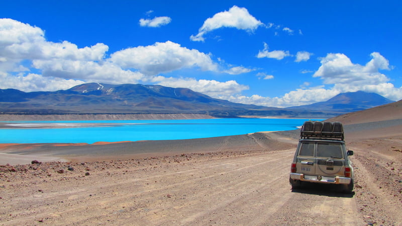
Laguna Santa Rosa - Laguna Verde (4350m)
We drive through an incredible landscape that leads us to Laguna Verde. We join the
international route to Argentina. We have a short drive today and this will give us time
enjoy a dip in the hot springs near Laguna Verde.
2 - 3 hour drive (BLD) camping
Day 6
Laguna Verde - Volcano San Francisco (6018m) - Laguna Verde
We start very early in the morning, with a transfer to the start of the climb. The
summit is at 6018m with views of all the surrounding mountains. The climb is on easy
terrain with some scree in places Same way back down and drive back in the afternoon
to Laguna Verde.
1 hour drive each way, 8 - 10 hours climbing (BLD) camping
Day 7
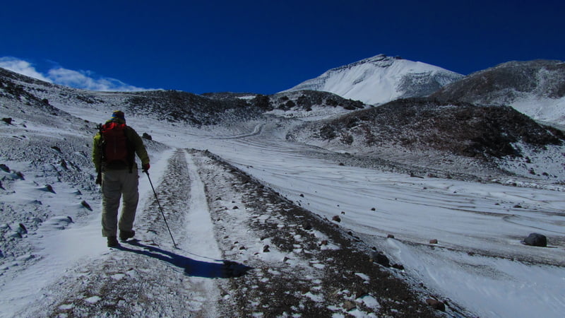
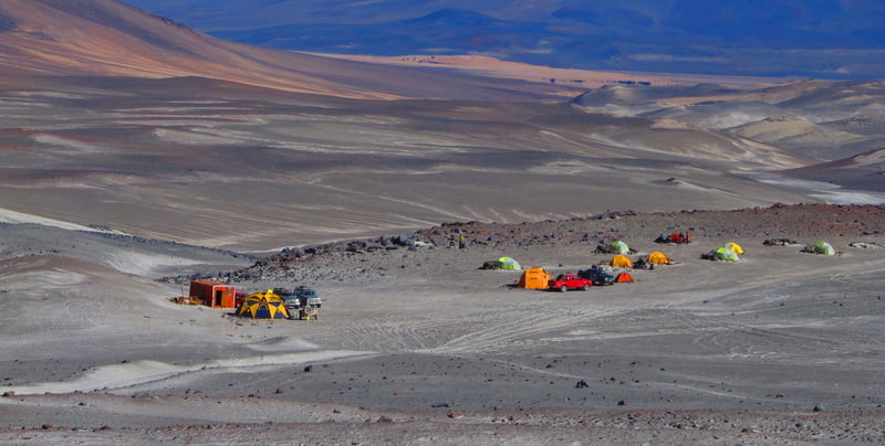
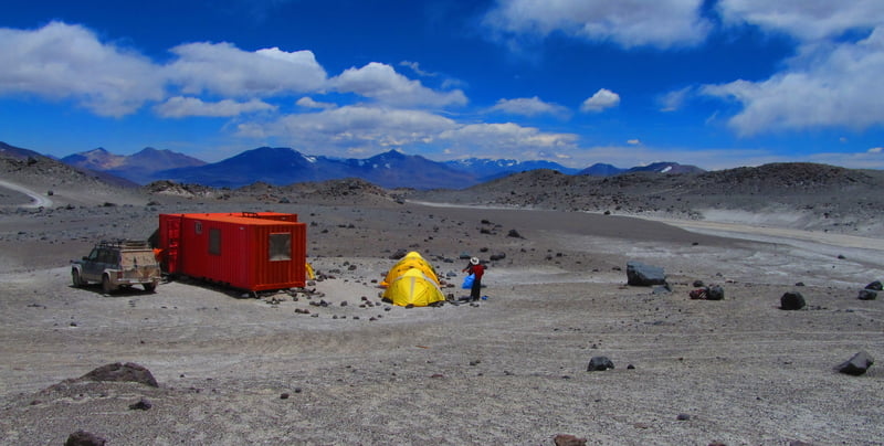
Laguna Verde (4350m) - Atacama, base camp (5300m)
Today we drive up to base camp. The road follows the dried out river beds. We cross
sand flats and steep rock, which are sometimes snow-covered slopes. At base camp
there is a small hut (Atacama refuge). This place will be our base camp for the next
days.
1 - 2 hour drive (BLD) camping

Day 8
Atacama Refugio (BC) -Tejos Refugio (5837m) - Base Camp
Today we carry some food and fuel to Camp I (Tejos). The trail is sandy and rocky.
We walk mainly on the road which is easy walking. Once at Tejos we drop our gear
inside the metallic hut. Here we have a rest and take a look around the area before
we head back down to base camp. The walk up and sleep low is to improve our
acclimatization.
5 - 7 hour trek (BLD) camping
Day 9
Rest day at Atacama Refugio (Base camp)
We use this day to rest and recover, before we go up to camp I and give the final push
to the summit, which will be physically demanding. We will prepare our gear for the
summit day. This day could be a reserve day in case we have bad weather.
(BLD) camping
Day 10
Atacama Refugio - Tejos Refugio (Camp I) (5825m)
Today we move up high camp, following the same trail. We also carry the rest of the
gear we will need for the summit day. We will arrive early to get hydrated and rest for
tomorrow's climb.
3 - 4 hour trek (BLD) camping
Day 11
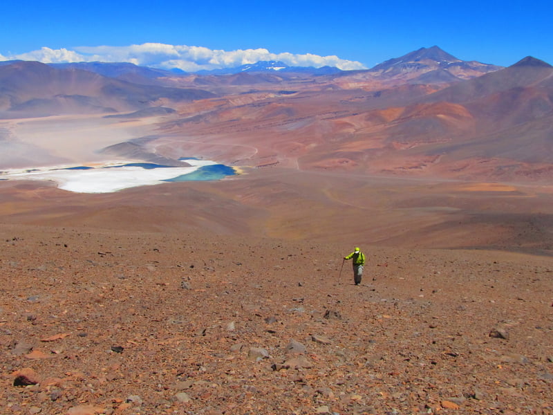
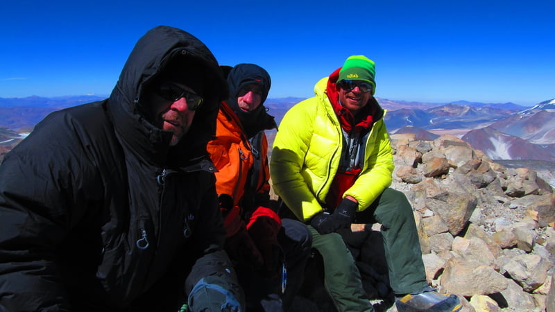
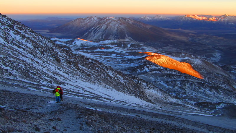
Tejos Refugio - Summit (6893m) - Tejos Refugio - Atacama Refugio
Starting very early in the morning, we climb 8 to 9 hours up to the summit. The route
follows a small zig zag trail up to around 6400m. From here the trail becomes loss on
pomes stones making the terrain loos, the ground that may be snowy or dry. This part
will take us to the carter rim and from here we can see the true summit. From the carter
rim there is a small track in the rock where we reach the final rock climb to the summit.
Normally there is a fixed rope in this section to help with this part. From this amazing
summit we will see all the major summits of the area, including Tres Cruces, Pissis just
to name a few. Depending on our time we can walk back down to Refugio Atacama.
12 - 18 hours climbing (BLD) camping
Day 12
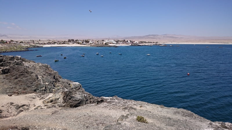
Atacama Refugio - Bahia Inglesa, Caldera (20m)
We dismantle the tents, organize the gear, pack the equipment and load the cars. We
drive back to Copiapó, and onto Bahia Inglesa next to the beach for a relaxing rest.
5 - 6 hour drive (BL) Hotel 3*
Day 13
Bahia Inglesa - Airport or Copiapo
Transfer to the airport, 20 minutes drive (B)
END of SERVICE
Users
average
Last update: Jeff Sandifort
(4 Feb 2019)