

Manaslu Circuit Trek
| Activity type: | Hiking |
| Activity level: | Moderate |
| Availability: |
12 Oct 2018 - 28 Oct 2018 |
| Duration: | 16 Day(s) / Tour with fixed start dates |
| Price: | from $1520 |
Full description
The Manaslu Circuit trek offers the amazing ethnic and scenic diversity, still relatively un-trekked; the lush rice paddies and traditional villages of Nepal's 'Middle Hills'. This Manaslu trek leads us to high Himalayan passes, purely Tibetan villages, spectacular snow-peak panoramas and wonderful campsites. The trekking around Manaslu has long been a restricted area due to the close proximity of the Tibetan border and is now open, but only for organized groups. The trek is geographically spectacular and culturally fascinating. The inhabitants of the upper Buri Gandaki, a region known as Nupri ('the western mountains'), are direct descendants of Tibetan immigrants. Their speech, dress, and customs are almost exclusively Tibetan. Gurung, Magar, Chhetri, and Tamang are the other inhabitants living on this trekking region. From the top of this pass, you are rewarded with a stunning panorama looking towards Himlung Himal (7,126m/23,379ft), Manaslu & the Annapurna peaks, with the peaks of Ganesh Himal (7,406m/24,298ft) rounding off the east. The descent passes is through the alpine meadows of Bimtang to join the renowned Annapurna Circuit at Thonje. Tillman first surveyed this region in 1950 on his reconnaissance of Annapurna.
Qualification: Manaslu Larkya La trek is an arduous trek and requires a good experience of trekking and a good physical condition.
Price includes
- All ground transportation in Kathmandu by private vehicle (Including airport pick and drop)
- 03 Nights twin sharing Deluxe accommodation in Kathmandu at Hotel Apsara Boutique on BB plan-
- Welcome dinner at one of the typical Nepalese restaurant- Traditional Dance & Music & Farewell Dinner at one of the finest restaurant in down town
- Manaslu Circuit Trek Permit, Annapurna Conservation Areas Project( ACAP) Permits & Fees & TIMs card
- Kathmandu to Arughat to Soti Khola transfer by private Jeep drive( 7 to 8 hours drive)
- Drive from Syange to Besisahar by available public bus/Jeep sharing and Besisahar to Kathmandu transfer by private vehicle
- Manaslu Circuit Trek on full board of meals (B, L, D, tea /coffee in cups only), seasonal fruits etc.
- Manaslu Circuit Trek accommodation in comfortable Mt. Lodges & Guest Houses on twin share- (Few Nights will be in attached bathroom/hot shower)
- One Advanced Adventures Trek Leader (Gov. Licensed, first aid, altitude trained/experienced and eco trained), assistance leader/s in a group, their entire expenses, equipment and insurance
- One trek porter to carry trek luggage’s for every two trekkers in a group, all payment, trekking equipment and insurance
- Sleeping Bags and Down Jacket for Trek use (Need to return after trek), Trek Duffle Bag and T- shirt, Trekking Maps & Adventure Certificate
- Group Medicine kit Box, with Diamox- AMS Medicine
- All Gov. and local taxes as applicable
- Final departure transfer from Kathmandu to airport on your departure
Not included in price
- Nepal Visa, International flights in/out Nepal
- Lunch & evening meals in Kathmandu (If any)
- Cost of beverages such as mineral water, coca cola, Beer etc., cost of battery charge, laundry etc. on trek
- Travel insurance (Must include Helicopter evacuation, Medical Exp. and trip cancellation)
- Personal trekking gears
- Personal nature expenses & Tips
- Any extending trips
Guide

Verified Profile
- Email address
- Phone number
I was born in a native mountain village called Gorkha.
Starting as an assistant guide since 1998 I am able to start my own company in Nepal. I serve as Destination Expert In Advanced Adventures Nepal.
Having years of experience serving as a guide I know every trail of Nepal. With the level of expertise I have & carefully researched Itineraries, I have received best guide award by Nepal Tour Guide Association.
Location
Nepal, Samagaun, Western Development Region, Gandaki
Day 1
Arrival Day in Kathmandu (1350m/4428ft)
Welcome to the land of Himalayas! On arrival in Tribhuvan International Airport in Kathmandu; Advanced Adventures Trek Guide will great you then transfer you to our trip hotel. Check in to hotel and free time for leisure. Late afternoon, we meet again and brief your upcoming Annapurna Panorama Trek with us and introduce our trekking team. Evening, we host welcome dinner (Eating Nepali Food) at one of the finest local restaurant with music and ethnic dance. Overnight Kathmandu.
Day 2
Half Day Guided Tour of Kathmandu Valley (1350m/4428
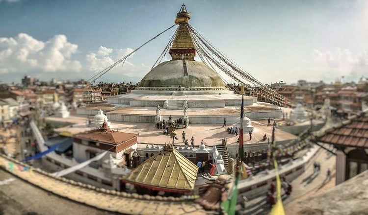
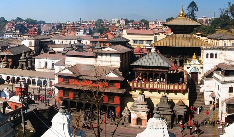
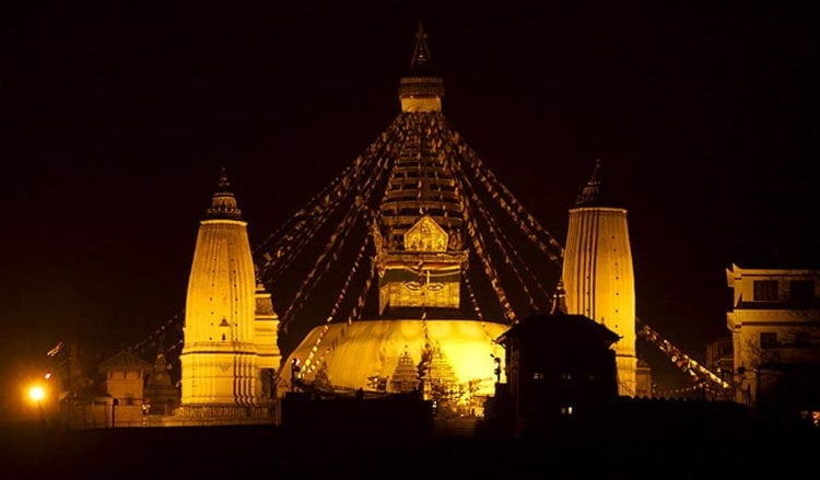
With easy morning and breakfast, today we will start the half day tour of Kathmandu Valley. Kathmandu Valley is probably one of the most interesting cultural valleys with superb blend of Hinduism and Buddhism and mega edifices dedicated to deities of these religions. Moreover, the historic courtyards and palaces inside Kathmandu are artistically fascinating, which date back to ancient and medeival eras. Firstly we will visit to the pilgrimage sites of Hindus- Pashupatinath Temple, one of the most important shrine of Shiva temples on the subcontinent which is an abode of thousand of devotees, Saddhus (holy men/Baba). The sights of cremating deads most of the times in the holy riverbank of Bagmati is offbeat cultural experience. From Pashupatinath we drive to nearby Buddhanath, the biggest Buddhist monastery in Asia- This Stupa is one of the holy Stupas for the entire Nepalese. You can circumambulate around this mega shrine clockwise to witness authentic Tibetan culture scattered everywhere at Boudhanath.
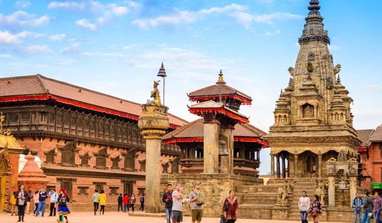
Next, we visit to Kathmandu Durbar Square which is old Royal palace of Kathmandu where we can see lot of temples built in different eras by different kings. The home to Kumari (Living goddess) manifests extremely fascinating architecture and walk in a freak street nearby reminds of Hippy era in Kathmandu. Afternoon, return back to hotel. Free time for shopping for trekking or packing. O/N at Kathmandu.
Day 3
Drive from Kathmandu to Aarughat (570 m) to Sotikhol
Altitude: 2394ft | Distance of Driving: 5-7 Hrs.
This morning, after an early breakfast, we will transfer you to Aarughat by Jeep (Takes about 5 hours), then fine another local Jeep (Road syndicate from local transport association) onward from Aarughat to Sotikhola, which takes another 2 hours. Most of the day drive is great through the Nepalese highway, through the river valleys and wonderful landscape. Our drive passes through, Dhading district (local areas of Malakhu, Dhading Besi- headquarter of Dhading District, Salyantar- great view of Ganesh Himal & Manaslu then to Aarughat). Aarughat is situated in riverbank of Budi Gandaki River Valley. And drive from Aarughat to Sotikhola is through the Gandaki Valley. O/N at Mt. Lodge in Sotikhola.
Day 4
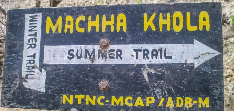
Trek from Sotikhola to Machhakhola
Altitude: 930m/3050ft | Distance of Walking: (10-12 kms)- 5-6 Hrs. Walks
From today, we will start our wonderful hike to Manaslu. Breakfast, and then start our walking following the riverbank of Gandaki Valley on steps ups and downs hills on narrow trail famous for donkey and horse, remote valley in Manaslu. While on trek today, we will pass through interesting and natural local villages of Khursanibari and Lapubesi to Machhakhola. After lunch, we will continue walking along a winding mountain overlooking the river through forested hill, and then it starts the wide and open valley of farmland as Machhakhola for overnight. Machhakhola is a small but pleasant village built on the slopes of the hill with several lodging options and a notable lodge development. There’s also a "Birthing Clinic” in the village and when the doctor’s here you can get some basic medicine and treatment if needed. O/N at Mt. Lodge in Machhakhola.
Day 5
Trek from Machhakhola to Jagat Village
Altitude: 1370m/4494ft | Distance of Walking: (12-14 kms)- 5-7 Hrs.Walks
Today, we will cross the Machhakhola then follow a narrow trail on the left bank of the Budi Gandaki following several ups and downs, and slippery rocks if rainy days. Tropical vegetation adds its charm, together with the thrilling suspension bridges that start to be a regular attraction in this trek. On reaching to Tatopani-990m (Natural Hot Spring spot, worth taking natural hot bath) and it is a tiny point of 2-3 houses on the narrow trail between the gushing Budhi Gandaki and a tremendous cliff. Further short walking brings us to the Dobhan (1070m), a small village with a basic lodging option. After an additional hour climb to Thado Bharyang, we will reach to Sauli. After a short waking from Sauli, the Gandaki is quite impressive as it descends rapidly in nice cascades. The valley then opens in Yuru (1330m) then to Jagat for tonight. In Jagat, it has MCAP office, where we would have to check in our trekking permit and MCAP ticket, and will be able to learn about MCAP activities in the region. Jagat is impressive village with its slate-paved streets giving it quite a tidy touch. It is relatively central village with an elementary school where 70 children from the nearby villages get their education. Villagers in Jagat make their living from Tourism, Agriculture, education, and government positions such as police check point and customs office.
Day 6
Trek from Jagat to Deng
Altitude: 1830m/6002ft | Distance of Walking: (14-16 kms)- 6 -7 Hrs. Walks
The trail from Jagat descends to the pleasant village of Salleri. It also has a slate paved main street, smiling locals and some lodges, then to Sirdibash, which is quite a ‘compact’ village with nice stone houses and slate roofs. Shortly, you will reach to the small village of Ghate Khola with 2 water-operated mills (Interesting to see even now how traditional way of grinding mills since ages alive!). In a short walking further, it crosses the suspension bridge over Budhi Gandaki River and step up to Philim, a big Gurung village. Philim is a central village in the area. It has a secondary school including accommodation for 300 children, supported by the Japanese. It has MCAP office as well for checked in to the region. We will have our lunch break here. Further, walk to Deng will pass by Ekle Bhati, nature to Nyak another Gurung village of this region. Deng Village itself is located on the mountain slope high above the trail. These days, new Mt. Lodge and Guesthouse has started here for tourist services. O/N at Deng.
Day 7
Trek from Deng to Namrung Village
Altitude: 2540m/8331ft | Distance of Walking: (12-14 kms)- 6-7 Hrs. Walks
Moving on north you pass through the tiny village of Rana gaon (1980m) with some dramatic views of the Budhi Gandaki gorge. Two hours walk from Deng you reach Bihi Phedi (1985m). From here, the trail climbs through the forest to the village of Prok (2380m). Prok is located on a small, surprising plateau above the river. It seems like a village stuck back in time, with beautiful traditional houses, large fields, welcoming residents and an interesting active local Gompas (Monasteries). Further, descend to Ghap, and then the trail goes into a charming fairy forest. Here, we do have two option trails to Namrung following upper route or lower route through forest. Before reaching to Namrung, the trail crosses the Budhi Gandaki twice on wooden bridges above beautiful gorges for Namrung. O/N at Mt. Lodge in Namrung.
Day 8
Trek from Namrung to Lho Village
Altitude: 3180m/10430ft | Distance of Walking: (10-12 kms)- 5-6 Hrs. Walks
The trail from Namrung goes through the beautiful small plateau of Bhanzam, with barley fields and stone houses in between. On the entrance to the village of Lihi branch right to a small flat area with 360 degrees view of the surrounding area. The attractions of Lhi are Barley terraces and chortens with carving of holy Buddhist mantras and sketches. After crossing the Hinang Khola, we will arrive to the village of Sho Lho Sho, Lho and Shyala Village. Today, we will have full evening to explore in Lho. A large Gompa that includes a home for more than 150 children that get their education here dominates Lho. The Gompa and its dormitories are located on the slopes of a hill above the village. The top of the hill is a recommended viewpoint to first (and some would say best) view of Mount Manaslu. Manaslu is seen here at its best, with its "fishtail” twin peaks. It is highly recommended to view Manaslu as it fades during sunset, but better during sunrise, when the morning glow shines on its top. You don’t have to climb all the way to the hilltop – the area above the Gompa gate is a perfect viewpoint. O/N at Mt. Lodge in Lho.
Day 9
Trek from Lho- Samagaun
Altitude: 3390m/11120ft | Distance of Walking: (10 kms)- 3-4 Hrs. Walks
The trail from Lho climbs through quite a beaten forest towards Shyala (352m), then the trail on crosses the slope that drains Punggen glacier and reaches Samagaon through a nice flat area where you will always see lovely views of Yaks grazing. O/N at Mt. Lodge in Samagaun.
Day 10
Day Exploration in Sama Gaun
Altitude: 3390m/11120ft. Acclimatization In Sama Gaun
Today, we will spend full day of acclimatization and exploration in Samagaon. Samagaon is a lovely village, where houses are aligned in rows along a small river and face nice courtyards. The fields are located on both sides of the village above its houses level. Lodges are located north of the village, and they are full of action especially during the Manaslu climbing expedition’s periods.Day trip could be taken from Samagaon to Manaslu Base Camp – the first station of the Manaslu expeditions, and villagers are often called to help carry stuff to and from the base camp, adding them a significant source of income. While spending extra day in Samagaun, you could do day trip to Manaslu Base Camp or visit to Punggen Gumba and enjoy exploring village etc. O/N at Samagaun at Mt. Lodge.
Day 11
Trek from Samagaun to Samdo
Altitude: 3800m12464ft | Distance of Walking: (10-12 kms)- 3-4 Hrs. Walks
Today, our trek to Samdo is short due to the altitude gain and acclimatization proposes. With easy morning and breakfast, then cross Budi Gandaki river through the wooden bridge in to the side stream. Here, it has intersection to go to, Manaslu Base Camp (on North) and to Samdo Village. From here, the trail ascent ups the village of Samdo. Samdo is a tiny lovely village located just under the majestic Samdo peak (6335m) and the Samdo glacier. Only few lodges are available here. From Samdo, we could also have option of making a day side trip to Tibetan Border (Subject to security). O/N at Guest House in Samdo
Day 12
Trek from Samdo to Dharmasala ( Also known as Larke Phedi)
ltitude: 4460m/14629ft | Distance of Walking: (10-12 kms)- 4-5 Hrs. Walks
From Samdo, the trail will continue passing through passing fields and old mani walls, then descend to the river and croos the wooden bridge to Larkya Bazaar which used to be a very famous old Bazaar for trading to this region peoples but now nothing really remains. From here, trail start to climb with view of huge Larkya Glaicer ahead. A final push over with steep climbing closed the Larkya Glacier and to reach Dharmasala for the overnight. Dharamshala is a wide gradual mountain slope with campsite and a lodge called "Larke Rest House”. It was renovated in 2011 and now equipped with Guest house facilities for overnight stay, but in off season, it could get closed. O/N at Guest House.
Day 13
Trek from Dharmasala to Larkya Pass (5213m/17099ft) & Trek D
Altitude: 3720m/12202ft | Distance of Walking: (14-16 kms)- 7-9 Hrs. Walks
This is “the big day” so an early start is must. With light and quick breakfast, with the support of headlamp or torch at early morning (5:00), start walking to Larkala passes. Immediately above from Dharmasala, the trail becomes rocky as it goes along a moraine. In almost of two hours walking, you reach a beautiful turquoise lake that reflects the surrounding snowy mountains. Depending on the season that you reach here, the lake could be partially frozen but in colder months, it may be totally frozen. Further, the trail climbs on numerous rocky moraines – hills. These rocky hills and snowy ridges beyond now surround you. Just before Larke pass there are several small shallow lakes, before the final climb to the prayer flags marking the first part of Larke Pass. It takes 4-5 hours to reach Larke Pass from Dharamshala. From the top, the mountain vista to the west is incredible - Himlung Himal (7126m), Chap Himal, Gyaji Kang, Kang Guru (6981m) and Annapurna II (7937m) seen great. Now after top, the trail is followed by a steep tiresome descend down through a slippery trail towards the moraine of Salpudanda glacier. The trail then becomes gradual as it goes along the moraine and parallel to Bhimtang glacier towards Bhimtang. O/N at Bhimang.
Day 14
Trek from Bhimtang to Tilje (2300m) then to Dharapani
Altitude: 1860m/6101ft | Distance of Walking: (12-14 kms)- 5-6 Hrs. Walks
Bhimtang is a small settlement with few guesthouses, surprising spot located between Bhimtang glacier and the slopes of Larke Himal range. View from Bhimtang is great on Annapurna’s with stunning views of Mt. Lamjung, Himlung, Annapurna and Mt. Manaslu itself. The vegetation here is lush and colorful, and the trail crosses the foot of the Bhimtang glacier through fantastic scenery. From here, we mostly descend through the rhododendron and firs forest and long pastures takes you to the lovely village of Tilche (2300m). And village has welcoming atmosphere, with a few lodges, and it is rich with agricultural activity.Exit the village through a stone arch, cross the Dudh Khola and follow along its embankment descending through scrub forest. The walls of the Marsyangdi Valley loom larger and finally the houses of Dharapani appear in the distance. Pass through Thonje via a wooden bridge and through a chorten-shaped arch and Dharapani lies across a long suspension bridge over the Marsyangdi. Dharapani is in the regular and famous trail to Annapurna Circuit. O/N at Dharapani.
Day 15
Trek from Dharapani to Syange Village
Altitude: 760/2493ft( Besisahar) | Distance of Walking: (10 kms)- 3-4 Hrs. Walks & 7-8 Hours Drive
Today, we will ahve easy walking down hill to Syange via beautiful river valley areas crossing through beautiful chamjaand jagat villages. From Syange, we will take available Jeep sharing drive to Besisahar. From Besisahar, we drive back to Kathmandu by private vehicle. Evening, we host farewell dinner in one of the finest restaurant in town, feedback of the trip. O/N at Kathmandu.
Day 16
Departure from Kathmandu
ltitude: 1350m/4428ft
Breakfast and free morning. Free time onwards. On time, transfer to airport for your flight back home and the trip ends.
Users
average
Last update: chet Bhatta
(29 Oct 2018)