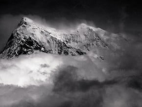
Dhaulagiri Base Camp Trek, Himalaya
| Mountain: | Dhaulagiri (8 167 m / 26 795 ft) |
| Activity type: | Hiking |
| Activity level: | Challenging |
| Elevation: | 5 360 m / 17 585 ft |
| Duration: | 13 Day(s) |
| Expenses: | from$ 1 500 |
Overview
| Route Name: |
Dhaulagiri Base Camp Trek, Trekking to the Dhaulagiri Base Camp, Треккинг в Базовый Лагерь Дхаулагири |
| Activity type: |
Hiking |
| Activity level: |
Challenging |
| Type of Climb: |
Trekking |
| Location: |
Asia, Nepal: (Western Region) |
| Starting Point: | |
| Parent Range: | |
| Mountain: | |
| First Ascent: |
1/1/2015 |
| Duration: |
13 Day(s) |
| Max. Elevation: |
5 360m / 17 585 ft |
| Vertical Gain: |
4 290m / 14 075 ft |
| Length: |
100km / 62 miles |
| Climbing Season(s): |
01 Apr-31 May; 01 Sep-30 Nov; |
| Nearst Airport(s): |
|
| Convenience Center(s): | |
| National Park(s): |
Location: Nepal
Activity type:Hiking
Difficulty: Moderate/ Challenging
Location: Nepal
Activity type:Hiking
Difficulty: Moderate/ Challenging
0 climber who were here
Naya Pul - Tikhedhunga. A good trail along the river goes through Birethanti (1015 m) and Hille (1495 m) and leads to Tikhedhunga (1577 m), where you can stay overnight at a local guesthouse (lodge).
Tikhedhunga - Ghorepani. At first there is a steep ascent to the village Ulleri (about 500 m with stone stairs). From Ulleri the trail ascends more gently through the fine forests and reaches Ghorepani where you can stay overnight at a lodge.
Ghorepani - Tatopani. The trail descends gently, ascending sometimes on little hills. There are hot springs in Tatopani. You can spend the night in a lodge.
Tatopani - Ghasa. The trail today gently ascends and goes through cypress and cedar's forest. In Ghasa overnight stay in a lodge.
Ghasa - Tukuche. On the right side of the river Kali Gandaki the road goes, where the main trail was, but there is a new trail on the left side of the river, There are bridges near Kalopani and Tukuche. The overnight stay in a lodge.
Tukuche - Yak Kharka. The trail ascends steeply to the meadows of Yak Kharka, the first overnight stay in tents.
Yak Kharka - Kalapani. The trail traverse the slope, ascending rather steeply at first, but then ascent becomes more gentle. After crossing several minor ravines, which may have water, there are a few flattened camping spots among the barren rock (at 4900 m). This is Kalapani (black water), the usual camping spot.
Kalapani - the Dhampus pass (5258 m) - Hidden Valley. From Kalapani the trail continues contouring and gently rising to the pass. The slope is quite steep and can be avalanche-pone. Descent to Hiden valley is gentle and snowy. From the Dhampus pass you can climb up to the Dhampus Peak (6035 m).
Hidden Valley - the French Pass (5360 m) - Dhaulagiri Base Camp. Ascent to the French Pass from the Hidden valley is gentle and snowy. The descent is gentle at first and marked with the cairns. First you follow the top of the moraine wall ant then abruptly descend to the glacier. This is steep and potentially dangerous passage, using the rope may be necessary. Once on the ice move quickly since avalanches can land uncomfortably close. The trail to the Dhaulagiri BC is usually clear and may be not the same as marked in the maps. Dhaulagiri BC is merely a collection of flat tent spots on glacier rubble and it is usually marked by flags.
The rest day in the Dhaulagiri Base Camp.
Dhaulagiri base camp - the French Pass – Hidden valley. First the trail continues by the glacier, then does up to the ledge, crosses the snow field and leads to a short but steep ascent to the saddle of the French pass. It can be really difficult because of the snow. Decent from the pass by the glacier is not a problem.
Hidden valley - the Dhampus Pass (5258 m) – Yak Kharka. The path to the Dhampus Pass is marked with cairns, but still it can be tricky to find them and the best way to the pass. The ascent is gentle and can be snowy. The descent is rather steep, first along snowy slopes. Then the trail leads to scree slopes, and then goes down and sometimes could be lost in the maze of yak trails.
Yak Kharka – Marpha - Jomsom. A very steep and long descent to Kali Gandaki valley. The main trail is well marked. From Marpha to Jomsom you can get trekking or rent a jeep.
show:
- 6
- 18
- 36
|
Availability
|

