-
Your Chance To
Edit •
Add / Share you knowledge with mates
The standard route upstairs - La Arista del Sol - is technically the easiest and is perfect for beginners and for those climbers who makes their first ascent in Mexico.
Meanwhile, in addition to 5-8 hours hikes on slopes of the volcano there are upgrades of 2-4 days and of a higher level of complexity, designed for experienced and trained mountaineers.
Adjacent to the mountain areas offer a huge range of hotels and climbing centers, making march on Iztaccihuatl very comfortable and civilized event.
Climbing on any of the four peaks guarantees a huge number of unforgettable views of the slopes of the mountains, the valleys at its foot, as well as other peaks of Iztaccihuatl.
-
Description
Edit •
Add / Share you knowledge with mates
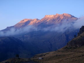
Iztaccihuatl is an extinct volcano, the third highest peak in Mexico and seventh in North America.
The name itself in the indian language means "white woman" that reflects the unique characteristics of the mountain's profile - looking at the mountain from different angles, one can clearly see the "head", "neck" and other "body parts" of this mountain.
The volcano has four peaks, the highest of which Pechora (el pecho - «chest") rises to 5,230 meters above sea level.
Iztaccihuatl attracts a huge number of local and foreign tourists, as a huge number of routes to the summit helps to realize their ambitions of climbing to a teenager as well as to experienced climbers with more than 20 climbing to the highest peaks of the world.
Located in the National Park Iztaccihuatl-Popocatepetl of total area of 25,679 hectares, where there is a place for very different natural zones and landscapes from tropical to alpine at high altitudes.
It's a rich center of natural resources, fully reflecting the richness of Mexican nature.
45% of all species of the country can be found here, the park is concentrates 5% of total national flora volume.
-
Listing
Edit •
Add / Share you knowledge with mates
-
Mexico State High Points
-
North America 14,000-foot Peaks (4 265 metres)
-
Location
Edit •
Add / Share you knowledge with mates
Iztaccihuatl volcano is located 70 km south-east of Mexico City in the states of Puebla and Mexico, and its tops can be seen from the capital, provided good sunny weather.
-
Getting There
Edit •
Add / Share you knowledge with mates
Traditionally in Mexico, the mountain can be reached from several major cities: from Mexico-City airport one should get to the bus station TAPO, which has several routes to the town of Amecameca (time of departure - every 15 minutes).
From Amecameca a taxi to La Joya, where one of the climbs begins.
Instead of buses, you can safely use the services of personal driver-guides who will deliver you directly to the trailheads from Mexico-City.
-
Red Tape
Edit •
Add / Share you knowledge with mates
To pass the gate from Paso de Cortez to La Joya you will need to buy a permit. The first option you have is you can go to the Izta-Popo National Park Headquarters located in the town square in Amecameca.
The other option is to get it at Paso de Cortez. The rangers at Paso de Cortez are not there at night so plan to arrive and get your permit in the morning or early afternoon.
At La Joya, there is a yellow box that contains the Socorro Alpino (Alpine Rescue) registration book. It is recommended that you sign in here.
-
Did You Know
Edit •
Add / Share you knowledge with mates
Iztaccihuatl (5230 meters) is one of the most accessible volcano in Mexico, offers a wide choice of routes to its four summits. It is a legendary mountain, firmly rooted into mythology and culture of the region. The name itself in the Indian language means "White Woman" that reflects the unique characteristics of the mountain's profile - looking at the mountain from different angles, one can clearly see the "head", "neck" and other "body parts" of this mountain. Plenty of options for climbing to the top, from quick ones to the ones designed for a few days - climbing the "White woman" is an interesting task at any time of year.
... Read more
-
Agencies
Edit •
Add / Share you knowledge with mates
-
References
Edit •
Add / Share you knowledge with mates


