

Ice Climbing
BeginnerMountaineering
BasicHiking
BeginnerRock Climbing
BeginnerBackcountry Skiing
BeginnerLuba Pershina
50 years, Russia
8 years ago
TOP-5 GUIDED CLIMBS IN ECUADOR - TIME, BUDGET, SCHEDULE AND OTHER ASPECTS YOU MUST KNOW
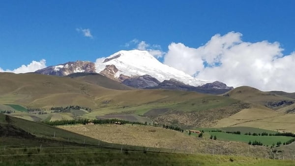
Ecuador is located in the equatorial part of South America and is limited on the north by Colombia, on east and south by Peru and its western part is limited by the Pacific Ocean. Ecuador in Spanish means "equator". The equator line runs 25 kilometres on north from Quito, the capital of the country, at an altitude of 3,000 meters above sea level, and its geographical coordinates are 0 degrees, 0 minutes, 0 seconds.
If you move from the south of the country to the north, towards the equator along the so-called "Volcano Prospect", then in the absence of clouds along the road you can observe the snow-capped peaks of the volcanoes Pasochoa, Corazon, Rumiñahui, Iliniza, Cotopaxi, Chimborazo, Tungurahua and many others. Some of them are beautiful and active volcanoes; others are extinct, suitable for climbing. This is one of the most beautiful mountain panoramas of the world; you can watch it directly from the window of a car or a bus. Imagine what a view you can enjoy from the top of one of them!
Geographically, Ecuador is divided into 3 regions. The west of the country, along the Pacific coast, the lowlands and the foothills of the Andes stretched out. The eastern part of the country is located within the Amazonian lowland. And between the ocean and the rainforest there are two mountain volcanic chains: the West and the Eastern Cordillera, which consist of many volcanoes: large and small, active and extinct. In these mountain ranges the country has at least 20 volcanoes, which start from Mount Sangay and stretch to the border with Colombia. These are the most famous volcanoes: Pichincha (4789 m), rising above Quito, the permanent volcano Tungurahua, near the famous town of Banos, Cotopaxi (5897m) - the highest active volcano and the colossal Chimborazo (6310 m) - the highest point of Ecuador.
Among all the volcanoes, there are the five peaks that are the most interesting for mountaineering: Chimborazo (6 310 m/ 20 702 ft), Cotopaxi (5 897 m/ 19 347 ft), Cayambe (5 790 m/ 18 996 ft), Antisana (5 753 m/ 18 875 ft) and Iliniza Norte (5 126 m/ 16 818 ft).
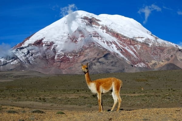
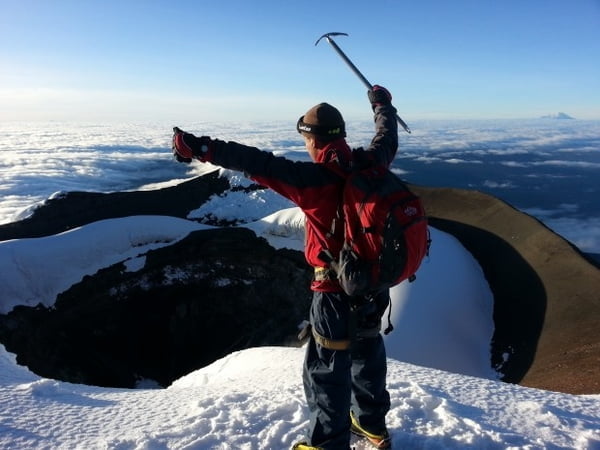
CHIMBORAZO (6 310 m/ 20 702 ft)
Chimborazo is the highest volcano in Ecuador. The top of Chimborazo (6310 m) is also the farthest point of its surface from the centre of the Earth. And once, until the beginning of the XIX century, it was considered the highest peak of the Earth. Especially because of this, from the XVIII century, many people tried to climb it. One of the most popular attempts was the ascent of the famous German scientist Alexander von Humboldt, in 1802 when he reached an altitude of 5875 m.
 Chimborazo Volcano. Photo by Edgar Parra
Chimborazo is technically a complex mountain, more suitable for climbers with climbing experience at altitudes bigger than 5000 meters and having strong crampon technical skills. The nature of the climb in the upper part of the route is rather difficult: moving along the medium-complex snowy slope with ice areas with steepness up to 45°. The presence of numerous crevasses on the glacier requires from climbers to use ropes, ice axes and even snow bars on the upper half of the route.
The weather conditions on Chimborazo change each year, and sometimes do not depend on the season. For example, I was lucky (at the end of November) to climb at a temperature of +2 Celsius at an altitude of 5200 meters, and with no trace of snow at all, approximately at 3 am, which is quite rare for any mountain. These were years of unprecedented warming on the mountain, which, of course, has its own microclimate, the conditions of which can only be predicted for 2 -3 days immediately before the ascent. Some of my friends and colleagues climbed with a lot of snow (again in a good season from November to February and in June-July!).
In addition to the unstable weather, in Chimborazo in some places there are frequent rock falls. This applies, above all, to the part of the route near Castillo, a rock formation in the form of a high cliff. It is especially dangerous to go there on a descent, therefore it is recommended to make a descent as early as possible, even in the first half of the day. Also, due to the difference in elevation between the shelter and the summit, the route requires serious physical effort in the sense of climbing speed. The upper shelter, Whymper (Refugio Whymper) is at an altitude of 5000 m. Since the exit should be at the top it is necessary to plan early (no later than 11 -12 am), it is necessary to start from the shelter at night, given the average ascent speed to the summit of Veintimilla, 10 hours. The descent usually takes from 4 to 5 hours, depending on fatigue and weather.
Therefore, I strongly recommend planning an ascent to Chimborazo only if you have the appropriate mountain experience, and most importantly, excellent physical preparation and altitude experience. And even in this case it will not be superfluous to take the help and professionalism of local Ecuadorian guides who know the mountain very well. And then, in conditions of maximum security and with a well-planned ascent, you have a great chance to ascend to the highest peak of Ecuador and see from a bird's eye view almost the whole country, from the ocean to the jungle.
Climbing the Chimborazo with a local Ecuadorian guide can have an average cost starting from $400 to $600 USD, depending on the duration of schedule you chose to dedicate to acclimatisation. Choose your guide very responsibly and take it seriously, because it will influence not only the success of the ascent, but also your safety. The Mountain Planet project gives each guide the opportunity to publish their climbing resumes, and lets other members leave a feedback to guide after the expedition. Read carefully the feedbacks as it is one of the most valuable information we can provide.
COTOPAXI (5 897 m/ 19 347 ft)
Cotopaxi is considered to be the third in the world and the highest active volcano of Ecuador. And for me it is also the most beautiful volcano in the world. Over the past two years, Cotopaxi has been very active, and climbing it wasn’t allowed. From its mouth, stones and ash flew out, and the volcano was completely covered even for the access of ordinary tourists. Most recently, on October 4, 2017, the Minister of the Environment of Ecuador announced the official opening of the Cotopaxi summit, calling the volcano "one of the main emblems of the country". And indeed, it is beautiful, with a white peak, surrounded by yellow-green fields with typical volcanic flora and fauna, it is the centre of the National Cotopaxi Park. Its peak is the most popular ascent with 5000m in Ecuador, thanks to convenient logistics and a good level of accommodation in the base camp, as well as a relatively quick ascent.
 Cotopaxi crater. Photo cortesy of Edgar Parra
Climbing Cotopaxi will be unique for you not only because during this season the volcano is really the highest of the most beautiful, really emblematic mountain of Ecuador. But it is also possible that all the climbers are given a stunning panorama from the top: you will see a field of clouds white as snow, and through them distant and close peaks of other volcanoes, all in the rays of the rising sun. And also, the kind of the crater is very interesting, an almost perfectly round cone that extends deeply into the interior. By the way, in the language of the indigenous Indians, Cotopaxi (Kutuphaksi) means the Neck of the Moon. Maybe it is because in the moonlight this snowy giant looks so fascinating. In other versions, the name of the volcano means "shining mountain" or "smoking mountain".
For those who already have experience of uncomplicated mountain climbing with 5000 m height, as well as experience with snow grips, this will be an ideal option for climbing. It will be necessary to overcome a number of large and beautiful crevasses, sometimes with beautiful pale blue ice, some of which, depending on the season, you will be able to cross through the snow bridges. Using different climbing techniques can also enrich your mountain experience, but most of all, of course, the experience of climbing at a height approaching 6000 m will be interesting. Therefore, in order to have a good experience, you must hire a local guide who will guide you through an endlessly changing path through crevasses and bergschrunds.
The regular route Rompe Corazones (Heart Breaker) starts from the Jose Rivas Shelter and goes to the right, bypassing the classic route, which is now closed. This is currently the only possible route to the summit. And it is not easy, because it passes among numerous cracks, bergschrund, through snow bridges, and sometimes with the necessity of using aluminium ladders for the most dangerous areas. The most important point and the main advice: climbing should start at night, to meet the dawn on top and avoid descending with melting snow over the crevasses. And the second important advice: take in team-mates and the best local guide, which will make your climb safe and really beautiful. This magnificent mountain is worth it.
Climbing Cotopaxi with a local Ecuadorian guide will cost you up to 500 US$. The expedition from your arrival to Quito until the descent from the top takes about 5 days. A list of all tours in Cotopaxi offered by local guides, can be viewed on our website, in the GUIDED TOURS section. Please note that some guides offer two-day tours to Cotopaxi, but you can choose them only if you have a suitable acclimatisation.
Also, local guides for sure will offer you to practice ice climbing on the ice wall of the glacier. Usually it is done to practice before climbing, and also just try yourself, perhaps for the first time in this fascinating form of climbing technique. Make sure you climb a couple of other volcanoes for acclimatization, with easier routes.
CAYAMBE (5 790 m/ 18 996 ft)
The extinct volcano of Cayambe is 5 810 m tall. It is the third largest in Ecuador. It is 65 km away from the capital of Ecuador, Quito, in the province of Pichincha, not far from the Pichincha city. Cayambe is the only volcano in the world to be located almost exactly on the equator line.
 Snow summit of Cayambe volcano. Photo: Edgar Parra
Climbing to the top of the volcano is slightly easier than the route to Cotopaxi. By moving along the stony path along the southern slope, you will reach the glacier, which is the only snow patch in the equatorial mountain range. However, Cayambe is a technically complex mountain due to the presence of many crevasses, and you must have strong ice axe and crampon technical skills. It is recommended to start climbing to the top of the volcano cayambe at 12 noon, in order to get back to the shelter by 11 am.
From the top of the volcano there is a magnificent view of the Cayambe-Coca National Park with its blue mountain lakes, the volcanic steppes of the "paramo" and the dense Ecuadorian rainforest. Another noteworthy fact is the presence of a large number of agricultural greenhouses near the volcano cayambe, in which locals cultivate roses. It turns out that more than half of these noble flowers arriving to Europe from South America are delivered from Ecuador. So I advise after climbing to stroll through the territory of this unique nature reserve - the impressions will be unforgettable.
The cost of guided tours to Cayambe starts from $250 USD per person, but the total cost depends on the amount of climbers in the group and on the duration of the climb.
ILLINIZA NORTE (5 126 m/ 16 818 ft)
Illiniza is a stratovolcano, that is, one of the inactive volcanoes in Ecuador. The volcano has two main peaks: Iliniza Norte (Northern Iliniza), 5125 meters above sea level, and Iliniza Sur (South Iliniza), which is 5246 meters high. The route to South Illiniza is easier than to South Illiniza, despite the fact that it is higher. The fact is that the South is covered with an ice cap, and for the most time of the year it is covered with snow. There is no North Glacier, but there is often a lot of snow.
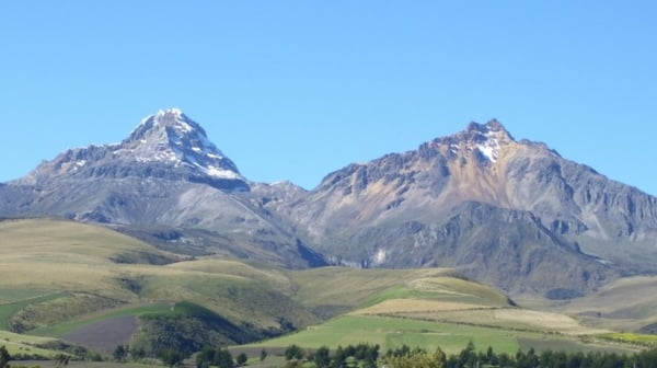 Illiniza Norte (right) and Sur (left)
Normal route first passes along the south-eastern ridge of the mountain, and gradually turns into a simple, but requiring constant attention, rock climbing. Nevertheless, the path is laid in such a way that special climbing preparation is not required. It is necessary only very carefully and slowly to move, to have suitable equipment, including a helmet, and pay special attention to the descent. The summit tower is the main difficulty of the route, and in some cases, depending on the weather, it is better to fix some ropes to get to the top safely.
Climbing Illiniza Norte is a very good acclimatization for further ascents in Ecuador. This mountain is used for preparation by most climbers before climbing higher peaks.
One of the most interesting details of the trip to this mountain is visiting the small town of Machachi, with its typical Ecuadorian Indian-Creole traditional culture.
ANTISANA (5 753 m/ 18 875 ft)
Antisana, a stratovolcano covered with ice, is 5704 meters tall. Located in the province of Napo, 50 kilometres from Quito, in the National Park of Antisana. It is the fourth highest volcano in Ecuador.
The English explorer and climber Eduard Wimper, and the Italian mountaineer Jean-Antoine Carrel were the first ones to get to the top of the volcano, in 1880.
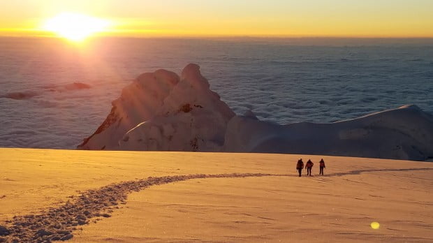 Sunrise at Antisana Volcano. Photo cortesy of Edgar Parra
The climbing permission is easy to obtain: the permission can be bought in Quito for $10 USD, or directly in the Hacienda from the owners of the territory.
As such, there is no such classic route to get on this mountain: the path must be searched among numerous crevasses and bergschrunds. You will need to fix some ropes to overcome an ice wall with a steepness of 65 degrees at an altitude of about 5000 m. Then the route will take you to the summit plateau, where the four peaks are located one after the other along the edge of the crater. Normally, almost the entire route is composed by ice, a beautiful giant and actively moving glacier. It is one of the largest equatorial ice massifs in the world.
The climb is quite technically difficult and rather dangerous due to very active glaciers, crevasses and avalanches. Finding a local guide (who could support you in this very interesting mountain adventure) is not so easy, so make sure you take care of this matter in advance. I recommend you to pick up a guide on the site www.mountainplanet.com, where convenient filtering mechanisms will help you choose the most suitable candidate. Check out his/her profile, look at the list of routes s/he climbed, and read reviews from other members.
Antisana is probably the most difficult peak in Ecuador. But this is both the most interesting mountain, and an exciting expedition to the present kingdom of snow and ice, to the "real" mountain, as not so many left in the world!
LIST OF THE MOST POPULAR CLIMBING AND HIKING ROUTES OF SOUTH AND CENTRAL AMERICA
6 Like
•
Luba Pershina
ALL YOU NEED TO KNOW TO CLIMB MOUNT ACONCAGUA SAFELY
4 Like
•
Luba Pershina
Аргентинская Патагония
3 Like
•
Luba Pershina
Top 5 Trekking Routes in Cusco Region, Peru. Why Your Trekking Time is Limited?
0 Like
•
Luba Pershina