

Ice Climbing
BeginnerMountaineering
BasicHiking
BeginnerRock Climbing
BeginnerBackcountry Skiing
BeginnerLuba Pershina
50 years, Russia
8 years ago
LIST OF THE MOST POPULAR CLIMBING AND HIKING ROUTES OF SOUTH AND CENTRAL AMERICA
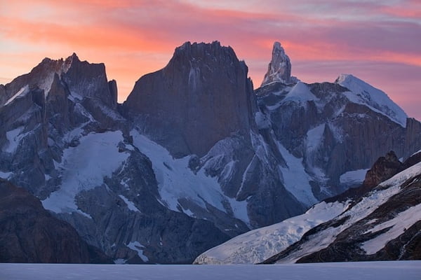 Argentinian Patagonia - Fitz Roy and Cerro Torre. Photo: Ivan Lukasevich
It has already begun! From early November until mid-March - this is the best time for trekking routes and climbing in the mountain regions of Mexico and South America. There are many routes, but among them there are five of the most interesting and unique ones from the nature and ancient people culture immersion point of view. These are the 5 places that cannot be avoided, especially if you think that you will visit South America only once or twice!
TREKKING ON THE INCA ROAD AND MACHU PICCHU
One of the most famous and beautiful tracking routes of the world is the so-called "Inca Road" (in Spanish ''Camino Inca''), or as it is sometimes called "The Inca Trail" in the Cusco region in Central Peru. The route is a way to the beautiful ancient citadel of South America, the Machu Picchu. This trekking is ideal for those who are just beginning to get acquainted with South America and simultaneously taking their first steps to the mountains.
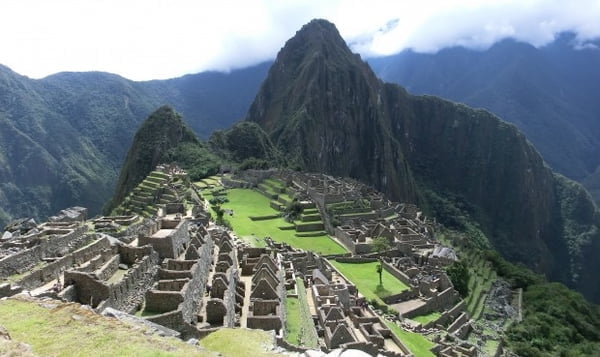 Machu Picchu. Photo: Luba Pershina
In Machu Picchu you will also be able to climb the sacred summit of Huayna Picchu. And besides, you can climb the mountain Machu Picchu, which rises above the fortress and the surrounding area. It will be a real ascent (about 2 hours) to the top, from which all the highest mountains of the region are visible.
Machu Picchu is the famous Incas' "fortress" in Central Peru in the area of the city of Cuzco, which never ceases to fascinate travellers with its natural mystery and natural beauty. You can take many pictures, and every step forward opens a new perspective.
But do you know what else is interesting about this citadel? There are things that not everyone knows, and not all guides will tell. I was at Machu Picchu maybe seven or eight times and I think I still don't know all its secrets. But I'm ready to share some of them.
Do you know that there are actually only three real Inca roads here? The bus road from below, on which tourists come, of course didn't exist before. Steep mountain slopes reliably protected the citadel. And the Inca roads, or rather their remains still exist. One of them is the famous Inca Trail, which I highly recommend you to go through!! But besides it there are two more trails that are not easy to detect, but in fact are stunning works of Inca buildings and military art.
Even those who have visited Machu Picchu more than once may not know the most beautiful route that runs along the river of the Machu Picchu. This is the river Urubamba or Vilkanota, the sacred river of the Incas. On the picture, it is on the bottom on the left, and it almost surrounds, as a horseshoe the rock massif on which the ancient city is located. The beauty of the river itself and the species from below upwards to Machu Picchu is simply fabulous, and even there in the middle of the road you can find a quiet place, such as a restaurant, and from it up the path to come to the waterfall, which is considered sacred.
There are many more secrets both outside and inside the Machu Picchu, and along the way to reach it, over which the last Inca ruler went to his sacred citadel for the last time. Only local guides will tell you these stories during the track or long walks around the citadel.
It is better to go to discover this fascinating place by foot and trekking along the Inca Road and with our mountain guide colleagues!! And my advice is to be accompanied by a local, even very modest, but necessarily Peruvian guide! This person really knows the history and culture of his land, because he loves it, lives on it, has listened the stories of his Indian grandparents, walked along paths and roads as a child, harvested corn and potatoes and sang folk songs. A local guide will tell you something more deeply humanistic about his land than people reading books and encyclopaedias, and he will remain your friend forever!
ARGENTINIAN PATAGONIA
Fitz Roy and Cerro Torre In Argentina, as the Argentines themselves admit, there is no ancient culture, but there is Buenos Aires, tango and gaucho! And there are cheerful and kind people. In Argentina there is a picturesque and harsh, but crazy in its beauty edge, Patagonia. It is a huge territory, on which there are mountains, steppes, ice and lakes, seas, roads, cities and a bottomless blue sky.
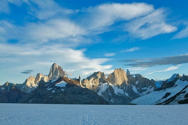 Argentinian Patagonia. Photo: Ivan Lukasevich
In the nearby there are monolithic granite walls of the famous stone towers of Cerro Torre and Fitz Roy. These towers are one of the most amazing natural landmarks of Patagonia. In these mountains, the sensation of the altitude is not the same as in the highlands of Europe and Asia, because the height of the very top of Cerro Torre is just 3128 meters above sea level. But the altitude here is different as a granite wall with a height difference of 1227 meters, its perfection and beauty, its escaping peak into the sky, the spire are the real sensation of altitude! Of course, you can just read the stories about her conquest, watch movies, and admire its pictures. But this won't replace the only possible way to discover the beauty of Argentinian Patagonia and its granite colossi unless you go there!
The monolithic peak of Fitz Roy is no less, and sometimes even more beautiful. It doesn't look exactly as on its best pictures, but it's impossible to stop watching at it! The changing palette of colours, the whole range of colours from pale pink to dark burgundy is possible only here, on this wall and in the clouds and skies surrounding it. Blue and green lakes, quaint trees and picturesque heaps of rocks, glaciers and moraines are unforgettable and indescribable. You just need to see it with your eyes!
Exactly here, between the Fitz Roy and Cerro Torre, pass both short and long trekking routes. There are several, different difficulties, and they all come out and return to the town of El Chalten. There is an opportunity to combine intense trekking with climbing, for example a pass or a simple top (Cerro Eléctrico). And also you can combine part of the trekking and part of the rest in the camp on the picturesque shore of the lake overlooking Fitz Roy and admire the dawn with a view of the walls of this granite giant.
The most popular destinations for such walks are the lakes Laguna de los Tres, Laguna Torre, Viedma Lake, Agachondas pass, Tunnel river and Polone river. If you already have a little experience of mountain tracks and you are truly in love with the mountains, then the Argentinian Patagonia is the place for you. It is here that you can make your first acquaintance with the techniques of movement along the mountain terrain, and do it at a low altitude above sea level, walk along moraines, over ice with snow grips, and try a crossed river crossing through a mountain river.
You can stay for a few days in a tent and climb to your first pass of your life. All this is relatively accessible and from a short distance from the nice hospitable town of Chalten. By the way, Fitz Roy, in the language of local Indians, is also called Chalten "the mountain that smokes". The climate of this region is severe (remember the "Roaring Forties"), and you can be covered by rain and wind for a few days, but always remember that above clouds there is a very blue sky! You just need to be able to look higher or just wait, enjoying nature and a good company (and strong Argentine mate or red wine).
The best time for trekking in Argentinian Patagonia is from December to the end of February. And even if you are not very lucky with the weather, all the same this trip is unique and will be remembered for your entire life, and the experience of walking and living in the mountains is invaluable. And of course, we recommend that you get to know Patagonia in the company of local Argentinian guides!
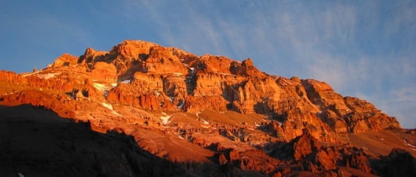
PICO DE ORIZABA VOLCANO
What is usually associated with Mexico? Cactus, tequila, spicy sauces, warm sea but not with high mountains. Even if they are there, indeed! And the highest peak is the Pico de Orizaba Volcano (5610 m.). Orizaba is the highest volcano in North America and the highest point of Mexico. Another name for this mountain is Citlaltépetl, which means "Hill of the Star" in the native language, but rather the Star-top. It is said that when the Spanish started to arrive to Mexico and on the coast of the state of Veracruz (the Gulf of Mexico), then from the ships in clear sunny weather, very bright spot was visible in the distance, like a big star. It was a mountain covered with ice and snow, or rather a volcano, which at that time was inactive. Indians, while explaining to the Spanish what was it, they used to call it a mountain-star. Also, there is an even more ancient name, Poyautécatl, or "the ground that reaches the clouds."
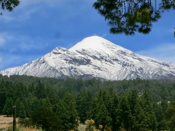 Pico de Orizaba. Photo: Luba Pershia
This mountain is very popular among American, European and even Asian climbers, who often use Orizaba as a training peak. Some Americans trace it to high-altitude ascents in South America or to Mount Denali, the highest peak in North America. It is not for nothing that it is the third highest peak on the North American continent. Also, it's much easier technically than, for example, the second highest one, Mount Logan, in Canada.
We recommend this climb to you if you already have an initial training in mountaineering, and you want to continue discovering new mountains and new people. Orizaba is an excellent peak for strengthening your high-altitude experience, and you can do it in quite comfortable conditions, without deep snows and avalanche slopes. The dome of the volcano is covered with snow and ice, while just 3 hours away on its slopes there are already growing cactuses, and just below and further is the warm sea (more precisely the Mexican Gulf of the Atlantic Ocean). By the way, it is often seen from the top with good weather. You can get to the Piedra Grande (Big Stone) accommodation at a height of 4200m with an old American jeep, the only transport mean here that can overcome the bumps and sands of the road leading to the top. On the slopes of the mountain to an altitude of 4000 meters grow pines, which is considered a unique of biological and geographical phenomenon.
Climbing Orizaba along the classic route through the Glaciar Jamapa is basically much easier than, for example, Elbrus or Mont Blanc. It's significantly cold there only during the last hour before sunrise when you are already at the bottom of the glacier. A snow slope up to 35 degrees steep in the first part of the glacier (and under the top to 45 degrees) does not represent a special technical difficulty, and offers an excellent opportunity to train with snow grips and an ice axe. However, it is better to have some experience with snow grips. And most importantly ask for help from local Mexican guides! With them, your ascent will not only be safer and faster (sometimes it is very difficult to find the right way of descent among the labyrinths of stones while leaving the glacier), but also interesting. I assure you, they will be able to tell you about their land much more than travel guides!
Mexico is a very original, bright and interesting country also thanks to its cuisine. Therefore, I strongly recommend that after the ascent you make a trip through this land of cactuses, colourful clothes, Aztec and Toltec pyramids, colonial cities, and white sand beaches. I recommend you to spend at least one week in Mexico in order to see at least some interesting places.
COTOPAXI VOLCANO
Let's fly a few thousand kilometres to the south, again to the South American continent, to Ecuador. The word "Ecuador" means "equator". It would seem that the equator crossing the country 25 kilometres north of the capital of Quito, as well as the famous Galapagos Islands, is the most important landmark of the country! But of course, for those who are interested in the mountains, the most important are the volcanoes of Ecuador.
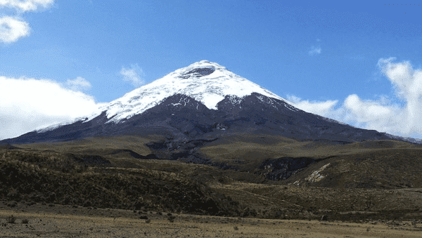 Cotopaxi Volcano. Photo: Edgar Parra
Over the past two years Cotopaxi has been active, indeed! It threw rocks and ashes, and the access was completely denied to climbers. But more recently, on October 4, 2017, Ecuador's Minister of Environment announced the official opening of the summit of Cotopaxi, calling the volcano "one of the main emblems of the country."
It is to this "emblem" of Ecuador that we are inviting you to climb! This climb will be unique not only because this season the volcano is really the highest of the existing ones. But it is also possible that all the climbers are given a stunning panorama from the top, you will see a white, soft field of clouds under your feet, and through them, distant and close peaks of other volcanoes, all in the rays of the rising sun. By the way, in the language of local Indians, Cotopaxi means the Neck of the Moon. Therefore, it is possible and in the moonlight nights this snowy giant looks fascinating.
For those who already have experience of uncomplicated ascents to the five-thousandths, as well as experience with snow grips, will be an ideal option for climbing. On the way to the top, you will have to overcome a number of large and beautiful cracks, sometimes with beautiful blue ice, some of which, depending on the season, you can cross the snow bridges. Climbing with ligaments can also enrich your mountain experience, but most of all, of course, the experience of climbing to a height approaching 6000 m. Also, local guides will definitely suggest you to practice climbing on the ice wall! Usually it is done to practice before climbing, and also just to try yourself, perhaps for the first time in this fascinating form of climbing technique is ice climbing!
If you have never been at such altitude, then you definitely need to make an ascent to this volcano. The good thing is that the living conditions at the Jose Ribas Shelter, almost directly under the ascent route, are exceptionally comfortable. So if you are already an advanced climber with an average experience, then you better face to Ecuador, to Cotopaxi!
MOUNT ACONCAGUA
If you are already quite an experienced mountaineer, and you have several high-altitude trekking and a couple of five thousand meters climbs on your back, then you definitely need to try yourself at high altitude and climb the Aconcagua!
 Mount Aconcagua. Photo: Luba Pershina
The Aconcagua name has several meanings in the translation from the languages of different indigenous Indian nationalities, but two of them seem to be the most beautiful: Snow Mountain and Stone Guard. The last one is most popular, and in fact, it seems to get closer to reality. In fact, there are very small amounts of snow on the mountain (the wind takes it all away or there is no precipitation). And the most important beauty of the mountain, which we can see from the Base Camp of the classical route, is Plaza de Mulas, its West Face, in the rays of the setting sun. And it really looks like Stone Guard.
Matthias Zurbriggen made the first ascent to the summit on January 14, 1897. It is believed that he ascended to the top alone. By the way, did you know that at an altitude of 5300 meters, in 1985, an Inca 7-year-old child mummy has been found sacrificed to the spirits of the mountains (or to Apus, the Sacred Heights) approximately in the 16th century. Five mountaineers who climbed the “southeast ridge” route found it. It means there was a Inca "religious" expedition. So who was really the first to climb this mountain?
Aconcagua is sometimes called a "trekking mountain," but in fact climbing it along the classic route from the Plaza de Mulas is not a trekking at all. This is a serious high altitude climb, often with the use of snow grips and with hurricane winds.
The most important difficulty of this climb is extremely dry and cold air at an altitude of more than 6000 m. From the geographical point of view, the terrain where the mountain is located is sometimes called the "high desert". And it really is a desert, and very beautiful, but insidious, because it takes from you all the available liquid. Another obstacle is that it never stops through the wind, which sometimes does not mind to throw you up when you have a light backpack.
But in fact, all these difficulties, inconveniences and dangers are nothing compared to the feeling of extraordinary freedom and flight when you are on the top. Descending it is relatively safe, but only with the condition of reaching the upper camp before it's dark! And of course, comfort and cosiness, and the special atmosphere of the Plaza de Mulas Base Camp, which happens only there: red wine, a must-have Argentinian steak (sorry vegetarians!), conversations in Spanish and English with several people at once: "how it was there at the top and like a descent, "calls home and always hot mate with contemplation of the red West Face.
But, as always, you can't list everything. And as usually I recommend you go there and experience it! Touch the sacred Great Mountain, try yourself at altitude, in the wind, on the water that you need to drink all the time. Finally, try, the famous Argentine red wine, already after the ascent below in Mendoza it will never be as tasty as up there! Try yourself at a height of almost 7000 meters, in fairly "comfortable" and safe conditions just by going on the Aconcagua!
And the most important advice is never go up to the mountain alone and even with another friend, even if you are an experienced climber with years of ascents and expeditions. Be sure to bring your local guide. More precisely, let him or her take you and show you his/her Mountain!
ALL YOU NEED TO KNOW TO CLIMB MOUNT ACONCAGUA SAFELY
4 Like
•
Luba Pershina
TOP-5 GUIDED CLIMBS IN ECUADOR - TIME, BUDGET, SCHEDULE AND OTHER ASPECTS YOU MUST KNOW
4 Like
•
Luba Pershina
Аргентинская Патагония
3 Like
•
Luba Pershina
Top 5 Trekking Routes in Cusco Region, Peru. Why Your Trekking Time is Limited?
0 Like
•
Luba Pershina