Mountain

Mountain Maudit (4 465 m / 14 649 ft)

Parent Range: Alps
Activity type: Mountaineering, Hiking, Backcountry Skiing
Summit(s): Main Summit (4 465 m /14 649 feet)
Elevation: 4 465 m / 14 649 ft
Cost of climbing: N/D
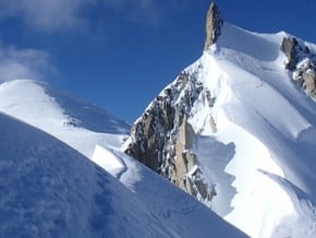
Image of Maudit (4 465 m / 14 649 ft)
Credit: www.masteringdiabetes.net

Facts

Mountain Name(s):
Maudit, Mont Maudit, Маудит
Elevation:
4 465 m / 14 649 ft
Summit(s):
Main Summit (4 465 m /14 649 feet)
Activity type:
Mountaineering, Hiking, Backcountry Skiing
Location:
Europe, France: (Rhône-Alpes), Italy: (Aosta Valley)
Starting Point:
Parent Range:
Range:
First Ascent:
12/9/1878 Johann von Bergen (Switzerland), Johann Jaun (Switzerland), William Edward Davidson (Great Britain), Henry Seymour Hoare (Great Britain)
Geology:
Tectonic
Snow line: Please update
Prominence:
162 m / 532 ft
Isolation:
1 m / 1 ft
Climbing Season(s):
01 Jun-15 Sep;
Nearst
Airport(s):
Convenience Center(s):
National
Park(s):
Please update

Location

Europe, France: (Rhône-Alpes), Italy: (Aosta Valley)
  • Your Chance To Edit •  Add / Share you knowledge with mates

    Interesting climbing one of the peaks of Mont Blanc massif above 4000 meters. The classic route is the same technical complexity, however, here there is something for those, who looking for something more challenging. The Mont Maudit has almost 40 different routes, that means almost as many as the Mont Blanc and Mont Blanc du Tacul. However, they are much less know than the famous and often climbed routes of the N- and E-side of the Mont Blanc du Tacul.
  • Description Edit •  Add / Share you knowledge with mates

    The southern side of the mountain is considerably steeper than the gentle snow slopes of the northern side and features the well-known southeast or Frontier ridge. The most popular for ascents sides are West and Northwest. You traverse these glacier flanks when climbing Mont Blanc via the Mont Blanc du Tacul starting from the Aiguille du Midi. As part of this Mont Blanc route, the Mont Maudit is interesting for "normal" alpinists who usually climb 4000m peaks. On this way, it takes already 6 to 7 hours from the Aiguille du Midi to the summit. The Southeast-side is completely different. It is similar to the rock scenery of the South-side of the Mont Blanc and the East- side of the Mont Blanc du Tacul. The Southeast of the Mont Maudit with its many couloirs, pillars, edges and faces is a very big challenge to climbers.
  • Listing Edit •  Add / Share you knowledge with mates

  • Location Edit •  Add / Share you knowledge with mates

    Located in Western Alps on the border of France (Haute-Savoie) and Italy (Aosta Valley). Lies in the Northeast of the Mont Blanc, 1,8 km far away from the main summit of the Mont Blanc.
  • Getting There Edit •  Add / Share you knowledge with mates

    From Geneva (Switzerland) to Chamonix (France) by car By car from Milan / Geneva / Turin region of Valle d'Aosta in the village Kurmaёr and then you can drive higher to the village of La Visaille
  • Did You Know Edit •  Add / Share you knowledge with mates

  • Agencies Edit •  Add / Share you knowledge with mates

  • References Edit •  Add / Share you knowledge with mates

Last update: Anastasia Pivnyuk (26 Oct 2016) • History

Other Mountains

Mountain

Location:South America, Chile:

Height: 5 410 m / 17 749 ft

Add to wishlist

Mountain

Location:Asia, Saudi Arabia:

Height: 1 139 m / 3 737 ft

Add to wishlist

Mountain

Location:North America, United States (USA):

Height: 1 884 m / 6 181 ft

Add to wishlist

Mountain

Location:Asia, Laos:

Height: 1 350 m / 4 429 ft

Add to wishlist
No one has been added yet

0 climber who were here

Sort by:

show:

  • 6
  • 18
  • 36

Join the growing Alpine Community now.