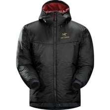
Arc'teryx Dually Belay Insulated Parka - Men's
Arc'-teryx


Material: 100% polyester Shoulder Straps: 2 padded Access: top zip Laptop Sleeve: yes, 15 in Dimensions: 19 x 11.75 x 5 in Recommended Use: casual, travel Manufacturer Warranty: limited 1 year

On May 29, 1953 history was created by Edmund Hilary and Tenzing Norgay when the duo successfully scaled the highest and dreaded mountain peak of the world.
Read more

Mountains can be dreadfully unforgiving. One needs to pay constant attention even when moving on well-known terrain... Mou...
|
Connect via: or
|
|
MOUNTAIN PLANET CONNECTS ADVENTURE GUIDES WITH OUTDOOR ENTHUSIASTS
Help us to make the mountains safer and more accessible to people by contributing secure information about routes, conditions, equipment and service providers
WHAT IS MOUNTAIN PLANET?
WHY SHOULD I REGISTER/SIGN UP?
|
We use cookies to enhance your visit to our site.