Nixon Get It Skinny Belt - Women's
Nixon
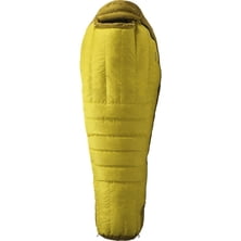
Material: Pertex Shield (2-layer, 30D), Pertex Microlight 30D Insulation: 800-Fill down Shape: mummy Max User Height: 6 ft, 6 ft 6 in Draft Tube: yes Storage Sack: yes, included Stuff Sack: yes, included Claimed Weight: 3 lbs 14.59 oz, 4 lbs 9 oz Recommended Use: hiking & camping Manufacturer Warranty: lifetime


48 Years,Australia
Posted on October 1, 2015
It's simply the best. Light, comfy and MEGAwarm. Choosing a size of sleeping bag please keep in mind that one size bigger provides you an extra space for boot's inners, wet socks and other stuff that need to be dried during the night.
Read more
The highlands of the Hindu Kush are home to small local groups who had escaped assimilation or destruction - Nuristan, Dard and eastern Iranian peoples. In the valleys preserved to this day ancient pre-Islamic religion.
Read more
Mountains can be dreadfully unforgiving. One needs to pay constant attention even when moving on well-known terrain... Mou...
|
Connect via: or
|
|
MOUNTAIN PLANET CONNECTS ADVENTURE GUIDES WITH OUTDOOR ENTHUSIASTS
Help us to make the mountains safer and more accessible to people by contributing secure information about routes, conditions, equipment and service providers
WHAT IS MOUNTAIN PLANET?
WHY SHOULD I REGISTER/SIGN UP?
|
We use cookies to enhance your visit to our site.