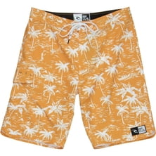
Rip Curl Jammer Board Short - Men's
Rip Curl


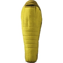
Material: Pertex Microlight (20D nylon ripstop), DWR treatment, Pertex Microlight (30D nylon) Insulation: 850+ fill goose down Shape: mummy Draft Collar: yes Zipper: left Max User Height: 6 ft, 6 ft 6 in Shoulder Circumference: 61 in, 63 in Hip Circumference: 57 in, 59 in Foot Circumference: 39 in, 41 in Bag Length: 83 in, 89 in Fill Weight: 28 oz, 30.7 oz Degree: 0 F European Norm Comfort Rating: 18 F European Norm Lower Limit Rating: 6 F Stuff Size: 7.5 x 16 in Stuff Sack: yes Storage Sack: yes Claimed Weight: 2 lb 12.27 oz, 2 lb 15 oz Recommended Use: camping, backpacking Manufacturer Warranty: lifetime

Often ranges Kongur Shan and situated north Muztagh Ata are considered as parts of Kunlun mountain range, are despite the fact that they are geographically closer to the Pamirs. In such a case, the highest point of the Kunlun is not Aksai Chin (Liushishi Shang) 7167 m, but Kongur Tagh (7,649 m and 7719 according to other sources)
Read more

The impossible is possible. There was a time when man thought that flying was impossible. There was a time when I thought it ...
|
Connect via: or
|
|
MOUNTAIN PLANET CONNECTS ADVENTURE GUIDES WITH OUTDOOR ENTHUSIASTS
Help us to make the mountains safer and more accessible to people by contributing secure information about routes, conditions, equipment and service providers
WHAT IS MOUNTAIN PLANET?
WHY SHOULD I REGISTER/SIGN UP?
|
We use cookies to enhance your visit to our site.