

Trekking News
7 years, Australia
7 years ago
Hiking the High Desert
Hiking the high desert of northeastern Nevada offers some great benefits, and challenges, due to the remote landscapes.
For example, Seitz Canyon on the west side of the Ruby Mountains gets few visitors. I had hiked into this canyon three times without seeing another person. On the fourth visit, however, I came around a corner in a thick aspen grove and encountered another hiker. We stopped and both of our faces registered annoyance at having our solitary hikes interrupted. We good-naturedly grumbled about the mountains filling up with people and then we went our own ways.
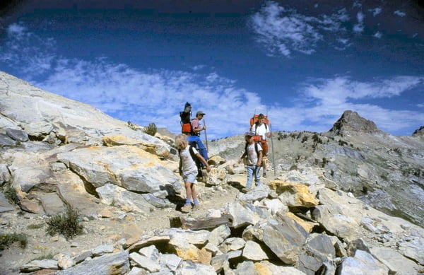
Not all trails in the high mountains of Nevada offer that level of solitude, but they do offer a chance to get away from other people. The Lamoille Lake Trail in the Ruby Mountains may be crowded on a summer weekend, but many other trails get very few hikers. The trails in the Jarbidge Mountains are so remote it is difficult to find out about them. People using the trails are loathe to share information.
Many of the trails access wilderness areas such as the Ruby Mountains Wilderness, the East Humboldt Wilderness and the Jarbidge Wilderness. In Nevada’s high mountain areas, it does not take much hiking to reach elevations of 9,000 or 10,000 feet.
Some high mountain trails are accessed only on bumpy two-track roads, using 4-wheel drive. But others can be easily accessed.
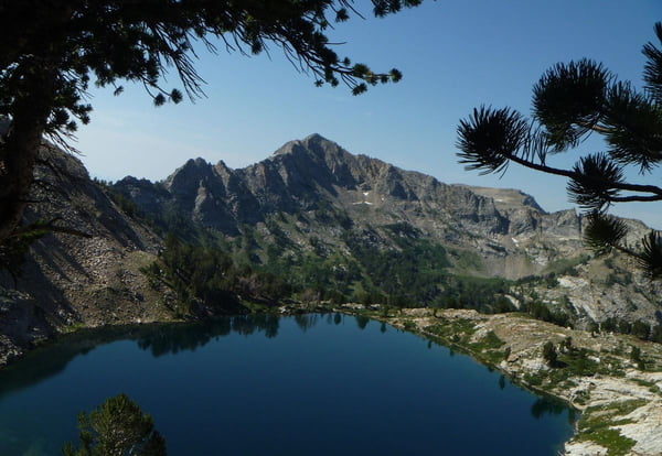
Smith’s Lake in the East Humboldt Range is one of my favorite destinations, only a 1.5-mile hike from Angel Lake and its paved access road. Yet this alpine lake is rarely visited by hikers.
Lamoille Canyon offers a paved road into the Ruby Mountains and access to several high trails, including the north end of the 40-plus mile long Ruby Crest Trail. The southern trailhead is accessed by a two-mile long, rough dirt road. Sometimes it is easier to hike the extra two miles and begin at a good, gravel, county road.
The problem with mountain solitude is that you are, well, alone. Some times you need other people, like if something goes wrong. Enjoyable solitude one day can become a nightmare the next day if you manage to injure yourself or become sick. Traveling in solitude requires hikers to be able to take care of themselves.
Self-reliance starts with others knowing where you are going and when you will return. Cellphone coverage in the mountains is spotty, at best. Solar-powered phone chargers can keep cellphones available for that rare coverage. Devices like the Spot satellite messenger can alert outside help.
High altitude hiking is exhilarating but there is always the chance of altitude sickness. Elevations over 8,000 feet offer less oxygen. A hiker leaving home at 3,000 feet, driving to a trailhead at 7,000 feet and hiking up to 9,500 feet, the elevation of many Ruby Mountains lakes, can face symptoms such as headaches, vomiting, tiredness, trouble sleeping and dizziness.
Symptoms of mild altitude sickness may appear that first night or the next day and go away a day or two later, as your body adjusts to the change in altitude. These symptoms can take the fun out of a trip.
A better plan might be to stay that first night in a town at 5,000 feet, or camp in a campground at 7,000 feet. Then hike the next day, giving your body an extra 24 hours to adjust to the altitude.
Even at high elevations inside wilderness areas, it is advisable to filter drinking water. No confirmed cases of Giardia have been reported in the Ruby Mountains but filters are so cheap to buy, and so easy to use, that it is not worth the risk of contracting this nasty intestinal disease.
Soldier Canyon offers a good trail giving access to Robinson Lake at 9,100 feet and Hidden Lakes at 9,500 feet. Most of the trail is inside the Ruby Mountains Wilderness. Dispersed campsites can be found in the canyon before the trailhead. Soldier Canyon dirt road is accessed off of the paved State Route 229, using the gravel Lower Lamoille Road. Get a map of the Ruby Mountains or stop at the U.S. Forest Service office in Wells or Elko.
Smith’s Lake trailhead can be reached by a paved road beginning in Wells. The lake is at 9,100 feet elevation and inside the East Humboldt Wilderness. The 1 ½ mile trail begins next to the Island Lake Campground at 8,400 feet.
Jarbidge Lake lies at 9,500 feet elevation and is surrounded by peaks over 10,000 feet. The Jarbidge River trail is mostly inside the Jarbidge Wilderness. The six-mile trail requires wading a stream close to the trailhead. The trail is most easily accessed by driving U.S. Highway 93 to Rogerson, Idaho, and then driving east through the town of Jarbidge to the trailhead. Jarbidge offers lodging, restaurants and bars. Dispersed campsites are available farther up the canyon.
A good hiking source is my “Hiker’s Guide; Trails in the Elko Area.”
by LARRY HYSLOP
This article first appeared on http://elkodaily.com. The original can be read here.
How to Hike with Kids? 9 Tricks from an Outdoor Mom
2 Like
•
Trekking News
This Gorgeous New 186-mile Trail Takes Hikers Through the Best of the Alps
2 Like
•
Trekking News
The Most Beautiful Day Hikes In America
2 Like
•
Trekking News
An Alternative View of Everest on a Base Camp Hike in Nepal
2 Like
•
Trekking News
Cape to Cairo: 12,000km on Foot
2 Like
•
Trekking News
Africa’s Top Trekking Destinations
2 Like
•
Trekking News
Opinion: The ‘Home of the Giants’ Is for You, Too
2 Like
•
Trekking News
DMZ Walks: Hiking Trails Open Along South and North Korean Border
2 Like
•
Trekking News
This Incredible Technology is Shaking up the Hiking World
2 Like
•
Trekking News
Explorer Celebrates His 70th Birthday by Trekking 1,250 Miles From the Tip of Cornwall to the Top of Scotland
2 Like
•
Trekking News
A Glimpse of Berber Life – Trekking in Morocco’s Atlas Mountains
1 Like
•
Trekking News
Annapurna Circuit: Trekking Route Connecting Touristic Hidden Lake Opened
1 Like
•
Trekking News
Yosemite Just Got a Quad-busting 94-mile Hiking Route
1 Like
•
Trekking News
Trekking Through Fire and Ice on Greenland’s 102-mile Arctic Circle Trail
1 Like
•
Trekking News
7 Hiking Boots for All Kinds of Travelers
1 Like
•
Trekking News
You Can Now Hike the Red Sea Mountain Trail in Egypt
1 Like
•
Trekking News
Trekking to Support Mental Health
1 Like
•
Trekking News
Nelson Mandela Bay’s Hiking Trails Offer Diverse Views and Terrain
1 Like
•
Trekking News
Сable Сar for Mount Kilimanjaro?
0 Like
•
Trekking News
Try Hiking or Climbing for a Refreshing Weekend
0 Like
•
Trekking News