Mountaineering
BeginnerHiking
BeginnerRock Climbing
BeginnerIce Climbing
BeginnerBackcountry Skiing
BeginnerMountain Planet
12 years, Australia
THREE WAYS TO GET THE BEST MOUNTAIN WEATHER FORECAST

In today's world, the weather forecast issue can be considered actually solved. City residents are already used to receiving these forecasts directly on their phones in just one click at any time. But in remote mountainous areas this function is not available, and it means that the alpine community has to solve this problem by other methods.
Mountain Planet has identified all the ways in which to get a weather forecast in the mountains, and then combined all answers into short essay about mountain weather forecasts.
Let's take a look at three ways to get a weather forecast in the mountains according to mountainplanet.com.
METHOD 1. NATURAL WAYS.
Sometimes the future weather can be predicted several hours before and even the day before without a synoptic map, relying only on natural ways. But for this, two conditions are necessary: firstly, you have to carefully observe the weather phenomena and, secondly, understand the movements and changes in the atmosphere that create weather changes.
According to British scientists, many natural ways are outdated, because at the time when they were created, there was a completely different climate. Winters were colder, summers weren’t so hot, and the natural ways were associated for other times, more precisely for other climatic epochs.
Nevertheless, the alpine community still trusts many natural ways, some of them are listed below:
- Cirrus clouds stay for bad weather for the next 36 hours. This is also indicated by the presence of high-cumulus clouds. If in the sky, you simultaneously observe both cirrus and high-cumulus clouds, most likely tomorrow there will be precipitation;
- Experienced climbers try to go on their summit push on full moon, as weather during full moon is the most stable;
- Strong wind in clear weather indicates a high atmospheric pressure, which may be a sign of the approaching bad weather;
- The east wind or the wind from the ocean can bring bad weather;
- If you see that the clouds are moving against the wind, you can expect weather deterioration.
Perhaps some of these natural methods will be useful and help you to notice the deterioration of the weather and correct the schedule of your outdoor adventure.
METHOD 2. MOUNTAIN FORECAST WEB SITES.
It's no secret that weather forecasting requires considerable computer power, together with an extensive network of meteorological stations to correct the mathematical model. Basically, all the free sites that pop up on the Internet take data from the same source and simply wrap this data into a high-quality media wrapper. Unfortunately, most of these sites do not provide a detailed weather forecast for mountain areas and peaks. To get the closest forecast, you can always look at the weather forecast for the nearest place. Of course, if this locality is too far from the point of interest, or located thousands of feet lower than your climb, then you shouldn’t completely trust this weather forecast.
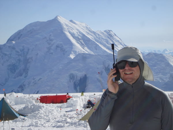
 Climber is receiving weather forecast at Mount Denali base camp (4300 meters ASL)
There are websites with weather forecasts that are designed for a specific category of users such as, climbers and mountaineers. These sites provide forecasts for a specific peak or mountainous area, and these weather forecasts can be provided for up to five different elevations. Typically, such websites have a free version, but you will have to pay to access detailed weather forecast.
For example, the website http://www.snow-forecast.com/ provides a free weather forecast for 6 days, but to get a 10 Day Snow Forecasts or 3-hourly Detailed Forecasts, you will need to purchase a 5 USD monthly subscription. It provides freezing levels, max/min temperature, relative humidity, snow forecast, maps, graphs, and more. You may also check their sidekick site https://www.mountain-forecast.com/ for peak specific forecasts since it has more user-friendly interface and detailed information for Alpine community. If there is no weather forecast for the desired peak, then check the weather forecast for the nearest one. The chances that these predictions will coincide are quite high.
METHOD 3. COMMERCIAL MOUNTAIN WEATHER CONSULTANCIES.
This method is the most reliable of all of the above, and consequently, the most expensive. But competition and modern technologies have allowed both to expand the range of providers of such services, and to significantly reduce their cost. Nevertheless, this industry is still in the initial stage of its development, and therefore the list of providers is still not large.
Every day at the same Greenwich time, all the weather stations in the world measure temperature, air humidity, wind speed, atmospheric pressure, rainfall and cloudiness. Balls-probes and artificial satellites of the Earth help to obtain data on the state of the upper layers of the atmosphere and take photographs of the planet's surface from the space. All this information flows into the world's weather data centers. The largest ones are located in Moscow, Washington and Melbourne, and consequently exchange this information between themselves.
The largest national meteorological services not only have access to information from these largest world data centers, but they can afford to pay for the work of the best specialists in the world to interpret these data. For example, in Meteo France there are narrow-profile specialists who are able to accurately determine the movement of air masses in the mountains and calculate their speed, that they can provide a weather forecast for any altitude anywhere in the world that will include detailed characteristics of the wind and atmospheric precipitation, visibility, cloudiness, temperature and atmospheric pressure. An individual weather forecast from Meteo France for a particular mountain or mountain range can only be purchased by super-expensive commercial expeditions (for example, to Everest or to Antarctica), and the cost of this service can reach thousands of dollars.
Some commercial mountain weather consultancies do not have the same capabilities as Meteo France, but offer more tailored approach to their users. For example, http://www.weather4mountain.com/ can supply you with specialist, timely and accurate weather forecasts for climbing, backcountry skiing or mountaineering, and even monitor your progress by tracker and send advance warning of potential hazards right to your mobile or satellite phone. The cost of this kind of services is also quite high and each tariff plan is selected individually. For example, the cost of one weather message can reach 7 USD, and a one-year subscription can cost up to 1500 USD.
The Mountain Planet project really hopes that this information will be useful not only for outdoor enthusiasts but also for advanced climbers. If you notice that we have not taken into account any important aspect of the topic discussed above, we encourage you to actively share this information with the alpine community through comments on this article.


